
Topografische kaart Brookfield
Interactieve kaart
Klik op de kaart om de hoogte weer te geven.
Over deze kaart
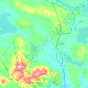
Naam: Topografische kaart Brookfield, hoogte, reliëf.
Locatie: Brookfield, Carroll County, New Hampshire, United States (43.50361 -71.12772 43.63303 -71.03692)
Gemiddelde hoogte: 235 m
Minimale hoogte: 142 m
Maximale hoogte: 554 m
According to the United States Census Bureau, the town has a total area of 23.2 square miles (60.2 km2), of which 22.8 sq mi (59.1 km2) are land and 0.42 sq mi (1.1 km2) are water, comprising 1.82% of the town. Brookfield is drained primarily by the Branch River and Pike Brook, within the Piscataqua River (coastal) watershed, though the western edge of the town is in the Merrimack River watershed and the northernmost tip of the town is in the Saco River watershed. Copple Crown Mountain, along the western border of Brookfield and the highest point in town, has an elevation of 1,868 feet (569 m) above sea level.
Andere topografische kaarten
Klik op een kaart om zijn topografie, zijn hoogte en zijn reliëf te bekijken.
Conway
United States > New Hampshire > Carroll County
Conway, Carroll County, New Hampshire, United States
Gemiddelde hoogte: 256 m
North Conway
United States > New Hampshire > Carroll County > Conway
North Conway, Conway, Carroll County, New Hampshire, 03860, United States
Gemiddelde hoogte: 173 m
Big Attitash Mountain
United States > New Hampshire > Carroll County > Bartlett
Big Attitash Mountain, Bartlett, Carroll County, New Hampshire, United States
Gemiddelde hoogte: 711 m
Eidelweiss Beach
United States > New Hampshire > Carroll County > Madison
Eidelweiss Beach, Madison, Carroll County, New Hampshire, United States
Gemiddelde hoogte: 236 m
East Wakefield
United States > New Hampshire > Carroll County > Wakefield
East Wakefield, Wakefield, Carroll County, New Hampshire, 03830, United States
Gemiddelde hoogte: 206 m
Center Conway
United States > New Hampshire > Carroll County > Conway
Center Conway, Conway, Carroll County, New Hampshire, 03813, United States
Gemiddelde hoogte: 142 m
Albany
United States > New Hampshire > Carroll County
Albany, Carroll County, New Hampshire, United States
Gemiddelde hoogte: 329 m
Melvin Village
United States > New Hampshire > Carroll County > Tuftonboro
Melvin Village, Tuftonboro, Carroll County, New Hampshire, 03850, United States
Gemiddelde hoogte: 181 m
Ferncroft
United States > New Hampshire > Carroll County
Ferncroft, Albany, Carroll County, New Hampshire, 03897, United States
Gemiddelde hoogte: 439 m
Center Sandwich
United States > New Hampshire > Carroll County > Sandwich
Center Sandwich, Sandwich, Carroll County, New Hampshire, 03227, United States
Gemiddelde hoogte: 227 m
Lees Mill
United States > New Hampshire > Carroll County > Moultonborough
Lees Mill, Moultonborough, Carroll County, New Hampshire, 03254, United States
Gemiddelde hoogte: 173 m
Wolfeboro Falls
United States > New Hampshire > Carroll County > Wolfeboro
Wolfeboro Falls, Wolfeboro, Carroll County, New Hampshire, 03894, United States
Gemiddelde hoogte: 181 m
Union
United States > New Hampshire > Carroll County > Wakefield
Union, Wakefield, Carroll County, New Hampshire, 03887, United States
Gemiddelde hoogte: 176 m
Kearsarge
United States > New Hampshire > Carroll County > Conway
Kearsarge, Conway, Carroll County, New Hampshire, 03847, United States
Gemiddelde hoogte: 272 m
Center Ossipee
United States > New Hampshire > Carroll County > Ossipee
Center Ossipee, Ossipee, Carroll County, New Hampshire, 03814, United States
Gemiddelde hoogte: 157 m
Chocorua
United States > New Hampshire > Carroll County > Tamworth
Chocorua, Tamworth, Carroll County, New Hampshire, 03817, United States
Gemiddelde hoogte: 202 m
Redstone
United States > New Hampshire > Carroll County > Conway
Redstone, Conway, Carroll County, New Hampshire, 03860, United States
Gemiddelde hoogte: 185 m
Silver Lake
United States > New Hampshire > Carroll County > Madison
Silver Lake, Madison, Carroll County, New Hampshire, United States
Gemiddelde hoogte: 162 m
West Ossipee
United States > New Hampshire > Carroll County > Ossipee
West Ossipee, Ossipee, Carroll County, New Hampshire, 03890, United States
Gemiddelde hoogte: 167 m
Hart's Location
United States > New Hampshire > Carroll County
Hart's Location, Carroll County, New Hampshire, United States
Gemiddelde hoogte: 706 m
Wonalancet
United States > New Hampshire > Carroll County > Tamworth
Wonalancet, Tamworth, Carroll County, New Hampshire, 03897, United States
Gemiddelde hoogte: 391 m
South Tamworth
United States > New Hampshire > Carroll County > Tamworth
South Tamworth, Tamworth, Carroll County, New Hampshire, 03883, United States
Gemiddelde hoogte: 265 m
Wolfeboro
United States > New Hampshire > Carroll County
Wolfeboro, Carroll County, New Hampshire, United States
Gemiddelde hoogte: 213 m
Flat Mountain
United States > New Hampshire > Carroll County > Sandwich
Flat Mountain, Sandwich, Carroll County, New Hampshire, United States
Gemiddelde hoogte: 629 m
Ossipee
United States > New Hampshire > Carroll County
Ossipee, Carroll County, New Hampshire, United States
Gemiddelde hoogte: 217 m
Lake Wentworth
United States > New Hampshire > Carroll County > Wolfeboro
Lake Wentworth, Wolfeboro, Carroll County, New Hampshire, United States
Gemiddelde hoogte: 180 m
Ossipee Lake
United States > New Hampshire > Carroll County > Freedom
Ossipee Lake, Freedom, Carroll County, New Hampshire, United States
Gemiddelde hoogte: 127 m
East Freedom
United States > New Hampshire > Carroll County > Freedom
East Freedom, Freedom, Carroll County, New Hampshire, United States
Gemiddelde hoogte: 144 m
South Chatham
United States > New Hampshire > Carroll County > Chatham
South Chatham, Chatham, Carroll County, New Hampshire, United States
Gemiddelde hoogte: 163 m
Mount Chocorua
United States > New Hampshire > Carroll County > Albany
Mount Chocorua, Albany, Carroll County, New Hampshire, United States
Gemiddelde hoogte: 736 m
Sawyers River
United States > New Hampshire > Carroll County > Hart's Location
Sawyers River, Hart's Location, Carroll County, New Hampshire, United States
Gemiddelde hoogte: 457 m
Wakefield
United States > New Hampshire > Carroll County
Wakefield, Carroll County, New Hampshire, United States
Gemiddelde hoogte: 218 m
Moultonborough
United States > New Hampshire > Carroll County
Moultonborough, Carroll County, New Hampshire, United States
Gemiddelde hoogte: 243 m
Goose Corner
United States > New Hampshire > Carroll County > Wolfeboro
Goose Corner, Wolfeboro, Carroll County, New Hampshire, 03984, United States
Gemiddelde hoogte: 189 m
Glen
United States > New Hampshire > Carroll County > Bartlett
Glen, Bartlett, Carroll County, New Hampshire, 03838, United States
Gemiddelde hoogte: 240 m
Sandwich
United States > New Hampshire > Carroll County
Sandwich, Carroll County, New Hampshire, 03259, United States
Gemiddelde hoogte: 373 m
Mount Washington Valley
United States > New Hampshire > Carroll County > Conway > North Conway
Mount Washington Valley, North Conway, Conway, Carroll County, New Hampshire, 03860, United States
Gemiddelde hoogte: 250 m
Tuftonboro
United States > New Hampshire > Carroll County
Tuftonboro, Carroll County, New Hampshire, United States
Gemiddelde hoogte: 256 m
Bill Rae Conservation Area
United States > New Hampshire > Carroll County > Wolfeboro > Stockbridge Corner
Bill Rae Conservation Area, Stockbridge Corner, Wolfeboro, Carroll County, New Hampshire, United States
Gemiddelde hoogte: 244 m
Brookfield
United States > New Hampshire > Carroll County > Brookfield
Brookfield, Carroll County, New Hampshire, 03872, United States
Gemiddelde hoogte: 195 m
Mount Willard
United States > New Hampshire > Carroll County > Hart's Location
Mount Willard, Hart's Location, Carroll County, New Hampshire, United States
Gemiddelde hoogte: 775 m
North Sandwich
United States > New Hampshire > Carroll County > Sandwich
North Sandwich, Sandwich, Carroll County, New Hampshire, 03259, United States
Gemiddelde hoogte: 233 m
Sanbornville
United States > New Hampshire > Carroll County > Wakefield
Sanbornville, Wakefield, Carroll County, New Hampshire, 03872, United States
Gemiddelde hoogte: 185 m
Thurley Mountain
United States > New Hampshire > Carroll County > Ossipee
Thurley Mountain, Ossipee, Carroll County, New Hampshire, United States
Gemiddelde hoogte: 386 m
Eaton
United States > New Hampshire > Carroll County
Eaton, Carroll County, New Hampshire, 03832, United States
Gemiddelde hoogte: 262 m
Thorn Hill
United States > New Hampshire > Carroll County > Bartlett
Thorn Hill, Bartlett, Carroll County, New Hampshire, 03838, United States
Gemiddelde hoogte: 311 m
Mirror Lake
United States > New Hampshire > Carroll County > Tuftonboro > Mirror Lake
Mirror Lake, Tuftonboro, Carroll County, New Hampshire, United States
Gemiddelde hoogte: 169 m
Intervale
United States > New Hampshire > Carroll County > Conway
Intervale, Conway, Carroll County, New Hampshire, 03845, United States
Gemiddelde hoogte: 198 m
Crawford Notch State Park
United States > New Hampshire > Carroll County > Hart's Location
Crawford Notch State Park, Hart's Location, Carroll County, New Hampshire, United States
Gemiddelde hoogte: 796 m
Effingham
United States > New Hampshire > Carroll County
Effingham, Carroll County, New Hampshire, 03882, United States
Gemiddelde hoogte: 188 m