
Topografische kaart Bentonville
Interactieve kaart
Klik op de kaart om de hoogte weer te geven.
Over deze kaart
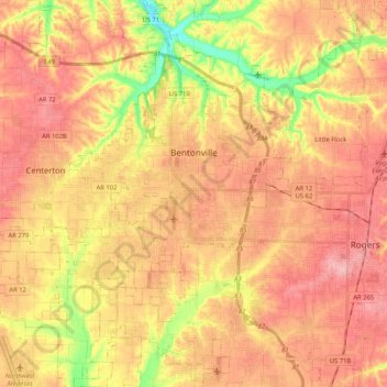
Naam: Topografische kaart Bentonville, hoogte, reliëf.
Locatie: Bentonville, Benton County, Arkansas, United States (36.27106 -94.32624 36.43871 -94.15459)
Gemiddelde hoogte: 387 m
Minimale hoogte: 309 m
Maximale hoogte: 436 m
Bentonville lies in the humid subtropical climate zone (Köppen Cfa) with influence from the humid continental climate type. Bentonville experiences all four seasons and does receive cold air masses from the north, however some of the Arctic masses are blocked by the higher elevations of the Ozarks. July is the hottest month of the year, with an average high of 89 °F (32 °C) and an average low of 66 °F (19 °C). Temperatures above 100 °F (37.8 °C) are common, with recent temperatures during summer months staying above 100 degrees for several weeks at a time. January is the coldest month with an average high of 46 °F (8 °C) and an average low of 24 °F (−4 °C). The city's highest temperature was 114 °F (45.6 °C), recorded in 1954. The lowest temperature recorded was −16 °F (−26.7 °C), in 1996.
Andere topografische kaarten
Klik op een kaart om zijn topografie, zijn hoogte en zijn reliëf te bekijken.
Lowell
United States > Arkansas > Benton County
Lowell, Benton County, Arkansas, United States
Gemiddelde hoogte: 404 m
Maysville
United States > Arkansas > Benton County
Maysville, Benton County, Arkansas, 72747, United States
Gemiddelde hoogte: 323 m
Gravette
United States > Arkansas > Benton County
Gravette, Benton County, Arkansas, United States
Gemiddelde hoogte: 356 m
Prairie Creek
United States > Arkansas > Benton County > Rogers
Prairie Creek, Rogers, Benton County, Arkansas, United States
Gemiddelde hoogte: 389 m
Garfield
United States > Arkansas > Benton County
Garfield, Benton County, Arkansas, 72732, United States
Gemiddelde hoogte: 453 m
Hiwasse
United States > Arkansas > Benton County > Gravette
Hiwasse, Gravette, Benton County, Arkansas, 72739, United States
Gemiddelde hoogte: 394 m
Siloam Springs
United States > Arkansas > Benton County
Siloam Springs, Benton County, Arkansas, 72761, United States
Gemiddelde hoogte: 339 m
Blowing Springs Bike & Fitness Park
United States > Arkansas > Benton County > Bella Vista
Blowing Springs Bike & Fitness Park, Bella Vista, Benton County, Arkansas, 72715, United States
Gemiddelde hoogte: 351 m
Centerton
United States > Arkansas > Benton County
Centerton, Benton County, Arkansas, 72719, United States
Gemiddelde hoogte: 393 m
Norwood
United States > Arkansas > Benton County
Norwood, Benton County, Arkansas, United States
Gemiddelde hoogte: 347 m
Bella Vista
United States > Arkansas > Benton County
Bella Vista, Benton County, Arkansas, 72715, United States
Gemiddelde hoogte: 372 m
Bentonville
United States > Arkansas > Benton County > Bentonville > Bentonville
Bentonville, Benton County, Arkansas, 72712, United States
Gemiddelde hoogte: 383 m
Rago
United States > Arkansas > Benton County > Bella Vista > Rago
Rago, Bella Vista, Benton County, Arkansas, 72715, United States
Gemiddelde hoogte: 378 m
Rogers
United States > Arkansas > Benton County
Rogers, Benton County, Arkansas, United States
Gemiddelde hoogte: 393 m