
Topografische kaart Arkansas
Interactieve kaart
Klik op de kaart om de hoogte weer te geven.
Over deze kaart
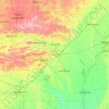
Naam: Topografische kaart Arkansas, hoogte, reliëf.
Locatie: Arkansas, United States (33.00425 -94.61788 36.49960 -89.64440)
Gemiddelde hoogte: 156 m
Minimale hoogte: 13 m
Maximale hoogte: 817 m
Arkansas's plant life varies with its climate and elevation. The pine belt stretching from the Arkansas delta to Texas consists of dense oak-hickory-pine growth. Lumbering and paper milling activity is active throughout the region. In eastern Arkansas, one can find Taxodium (cypress), Quercus nigra (water oaks), and hickories with their roots submerged in the Mississippi Valley bayous indicative of the deep south. Nearby Crowley's Ridge is the only home of the tulip tree in the state, and generally hosts more northeastern plant life such as the beech tree. The northwestern highlands are covered in an oak-hickory mixture, with Ozark white cedars, cornus (dogwoods), and Cercis canadensis (redbuds) also present. The higher peaks in the Arkansas River Valley play host to scores of ferns, including the Woodsia scopulina and Adiantum (maidenhair fern) on Mount Magazine. Arkansas wildlife is famous for the white-tailed deer, elk, and bald eagle. The white-tailed deer is the official state mammal.
Andere topografische kaarten
Klik op een kaart om zijn topografie, zijn hoogte en zijn reliëf te bekijken.
Brooklyn
United States > New York > New York
Brooklyn, Kings County, New York, United States
Gemiddelde hoogte: 9 m
Houston
United States > Texas > Harris County
Houston, Harris County, Texas, United States
Gemiddelde hoogte: 25 m
Albuquerque
United States > New Mexico > Bernalillo County
Albuquerque, Bernalillo County, New Mexico, United States
Gemiddelde hoogte: 1.688 m
Boulder
United States > Colorado > Boulder County
Boulder, Boulder County, Colorado, United States
Gemiddelde hoogte: 1.785 m
Appalachian Mountains
United States > North Carolina > Yancey County
Appalachian Mountains, Yancey County, North Carolina, United States
Gemiddelde hoogte: 1.463 m
Des Moines
United States > Iowa > Polk County
Des Moines, Polk County, Iowa, United States
Gemiddelde hoogte: 264 m
New Orleans
United States > Louisiana > Orleans Parish
New Orleans, Orleans Parish, Louisiana, United States
Gemiddelde hoogte: 1 m
Santa Cruz
United States > California > Santa Cruz County
Santa Cruz, Santa Cruz County, California, United States
Gemiddelde hoogte: 89 m
Arlington
United States > Massachusetts > Middlesex County
Arlington, Middlesex County, Massachusetts, United States
Gemiddelde hoogte: 35 m
Worcester
United States > Massachusetts > Worcester County
Worcester, Worcester County, Massachusetts, United States
Gemiddelde hoogte: 186 m
Amelia Island
United States > Florida > Nassau County > Fernandina Beach
Amelia Island, Fernandina Beach, Nassau County, Florida, 32034, United States
Gemiddelde hoogte: 3 m
Manhattan
United States > New York > New York County > New York
Manhattan, New York County, New York, United States
Gemiddelde hoogte: 16 m
Brunswick County
United States > North Carolina
Brunswick County, North Carolina, United States
Gemiddelde hoogte: 9 m
Fairfax County
Fairfax County, Virginia, United States
Gemiddelde hoogte: 75 m
Bronx County
United States > New York > New York
Bronx County, The Bronx, New York, United States
Gemiddelde hoogte: 21 m
Lexington
United States > Kentucky > Lexington
Lexington, Fayette County, Kentucky, 40508, United States
Gemiddelde hoogte: 285 m
Whatcom County
Whatcom County, Washington, United States
Gemiddelde hoogte: 753 m
Irvine
United States > California > Orange County
Irvine, Orange County, California, United States
Gemiddelde hoogte: 66 m