
Topografische kaart Massachusetts
Interactieve kaart
Klik op de kaart om de hoogte weer te geven.
Over deze kaart
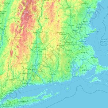
Naam: Topografische kaart Massachusetts, hoogte, reliëf.
Locatie: Massachusetts, United States (41.18886 -73.50821 42.88678 -69.86010)
Gemiddelde hoogte: 128 m
Minimale hoogte: -7 m
Maximale hoogte: 1.159 m
Despite its small size, Massachusetts features numerous topographically distinctive regions. The large coastal plain of the Atlantic Ocean in the eastern section of the state contains Greater Boston, along with most of the state's population, as well as the distinctive Cape Cod peninsula. To the west lies the hilly, rural region of Central Massachusetts, and beyond that, the Connecticut River Valley. Along the western border of Western Massachusetts lies the highest elevated part of the state, the Berkshires, forming a portion of the northern terminus of the Appalachian Mountains.
Andere topografische kaarten
Klik op een kaart om zijn topografie, zijn hoogte en zijn reliëf te bekijken.
Sacramento
United States > California > Sacramento County
Sacramento, Sacramento County, California, United States
Gemiddelde hoogte: 10 m
New Orleans
United States > Louisiana > Orleans Parish
New Orleans, Orleans Parish, Louisiana, United States
Gemiddelde hoogte: 1 m
Central Park
United States > New York > New York County > New York
Central Park, New York County, New York, United States
Gemiddelde hoogte: 26 m
Boulder
United States > Colorado > Boulder County
Boulder, Boulder County, Colorado, United States
Gemiddelde hoogte: 1.785 m
Norfolk
United States > Virginia > Norfolk
Norfolk, Virginia, 23510, United States
Gemiddelde hoogte: 4 m
Indianapolis
United States > Indiana > Indianapolis
Indianapolis, Marion County, Indiana, 46204, United States
Gemiddelde hoogte: 241 m
Madison
United States > Wisconsin > Dane County
Madison, Dane County, Wisconsin, United States
Gemiddelde hoogte: 284 m
Highlands Ranch
United States > Colorado > Douglas County
Highlands Ranch, Douglas County, Colorado, 80126, United States
Gemiddelde hoogte: 1.758 m
Fort Lauderdale
United States > Florida > Broward County
Fort Lauderdale, Broward County, Florida, United States
Gemiddelde hoogte: 5 m
Blue Ridge Parkway
United States > North Carolina > Watauga County
Blue Ridge Parkway, Watauga County, North Carolina, United States
Gemiddelde hoogte: 505 m
Ruidoso
United States > New Mexico > Lincoln County
Ruidoso, Lincoln County, New Mexico, United States
Gemiddelde hoogte: 2.287 m
Brooklyn
United States > New York > New York
Brooklyn, Kings County, New York, United States
Gemiddelde hoogte: 9 m
Kitsap County
Kitsap County, Washington, United States
Gemiddelde hoogte: 138 m
Hillsborough County
Hillsborough County, Florida, United States
Gemiddelde hoogte: 20 m
Fresno
United States > California > Fresno County
Fresno, Fresno County, California, United States
Gemiddelde hoogte: 98 m
Cedar City
United States > Utah > Iron County
Cedar City, Iron County, Utah, United States
Gemiddelde hoogte: 1.975 m
Coeur d'Alene
United States > Idaho > Kootenai County
Coeur d'Alene, Kootenai County, Idaho, United States
Gemiddelde hoogte: 719 m
Breckenridge
United States > Colorado > Summit County
Breckenridge, Summit County, Colorado, 80424, United States
Gemiddelde hoogte: 3.072 m
Staten Island
United States > New York > New York
Staten Island, Richmond County, New York, United States
Gemiddelde hoogte: 9 m