
Topografische kaart Washington
Interactieve kaart
Klik op de kaart om de hoogte weer te geven.
Over deze kaart
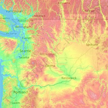
Naam: Topografische kaart Washington, hoogte, reliëf.
Locatie: Washington, United States (45.54372 -124.83609 49.00244 -116.91599)
Gemiddelde hoogte: 796 m
Minimale hoogte: -2 m
Maximale hoogte: 4.170 m
Washington is the 18th-largest state, with an area of 71,362 square miles (184,830 km2), and the 13th-most populous state, with more than 7.7 million people. The majority of Washington's residents live in the Seattle metropolitan area, the center of transportation, business, and industry on Puget Sound, an inlet of the Pacific Ocean consisting of numerous islands, deep fjords, and bays carved out by glaciers. The remainder of the state consists of deep temperate rainforests in the west; mountain ranges in the west, central, northeast, and far southeast; and a semi-arid basin region in the east, central, and south, given over to intensive agriculture. Washington is the second most populous state on the West Coast and in the Western United States, after California. Mount Rainier, an active stratovolcano, is the state's highest elevation at 14,411 feet (4,392 meters), and is the most topographically prominent mountain in the contiguous U.S.
Andere topografische kaarten
Klik op een kaart om zijn topografie, zijn hoogte en zijn reliëf te bekijken.
College Station
United States > Texas > Brazos County
College Station, Brazos County, Texas, United States
Gemiddelde hoogte: 87 m
Houston
United States > Texas > Harris County
Houston, Harris County, Texas, United States
Gemiddelde hoogte: 25 m
Sacramento
United States > California > Sacramento County
Sacramento, Sacramento County, California, United States
Gemiddelde hoogte: 10 m
Madison
United States > Wisconsin > Dane County
Madison, Dane County, Wisconsin, United States
Gemiddelde hoogte: 284 m
Spokane
United States > Washington > Spokane County
Spokane, Spokane County, Washington, United States
Gemiddelde hoogte: 655 m
New Orleans
United States > Louisiana > Orleans Parish
New Orleans, Orleans Parish, Louisiana, United States
Gemiddelde hoogte: 1 m
Staten Island
United States > New York > New York
Staten Island, Richmond County, New York, United States
Gemiddelde hoogte: 9 m
Central Park
United States > New York > New York County > New York
Central Park, New York County, New York, United States
Gemiddelde hoogte: 26 m
Boulder
United States > Colorado > Boulder County
Boulder, Boulder County, Colorado, United States
Gemiddelde hoogte: 1.785 m
Texarkana
United States > Texas > Bowie County
Texarkana, Bowie County, Texas, United States
Gemiddelde hoogte: 99 m
Queens County
United States > New York > New York
Queens County, New York, United States
Gemiddelde hoogte: 11 m
Albuquerque
United States > New Mexico > Bernalillo County
Albuquerque, Bernalillo County, New Mexico, United States
Gemiddelde hoogte: 1.688 m
Norfolk
United States > Virginia > Norfolk
Norfolk, Virginia, 23510, United States
Gemiddelde hoogte: 4 m
Fort Lauderdale
United States > Florida > Broward County
Fort Lauderdale, Broward County, Florida, United States
Gemiddelde hoogte: 5 m
Ruidoso
United States > New Mexico > Lincoln County
Ruidoso, Lincoln County, New Mexico, United States
Gemiddelde hoogte: 2.287 m
Brooklyn
United States > New York > New York
Brooklyn, Kings County, New York, United States
Gemiddelde hoogte: 9 m