
Topografische kaart Tulelake
Interactieve kaart
Klik op de kaart om de hoogte weer te geven.
Over deze kaart
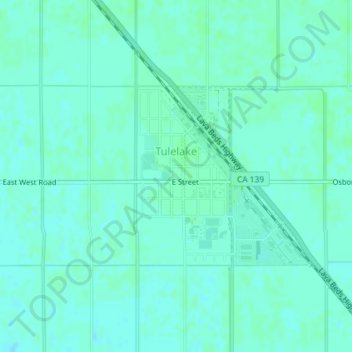
Naam: Topografische kaart Tulelake, hoogte, reliëf.
Gemiddelde hoogte: 1.230 m
Minimale hoogte: 1.227 m
Maximale hoogte: 1.233 m
Tulelake (/ˈtuːlileɪk/ TOO-lee-layk) is a city in Northeastern Siskiyou County, California, United States, at an elevation of 4,066 feet (1,239 m) above sea level. The town is named after nearby Tule Lake. The population was 1,010 at the 2010 census, down from 1,020 at the 2000 census. In an unusual circumstance, at least within California
Andere topografische kaarten
Klik op een kaart om zijn topografie, zijn hoogte en zijn reliëf te bekijken.
Weed
United States > California > Siskiyou County
Weed, Siskiyou County, California, 96094, United States
Gemiddelde hoogte: 1.116 m
Mount Shasta
United States > California > Siskiyou County
Mount Shasta, Siskiyou County, California, United States
Gemiddelde hoogte: 3.717 m
Canyon Mountain
United States > California > Siskiyou County
Canyon Mountain, Siskiyou County, CAL Fire Northern Region, California, United States
Gemiddelde hoogte: 1.026 m
Miller Mountain
United States > California > Siskiyou County
Miller Mountain, Siskiyou County, CAL Fire Northern Region, California, United States
Gemiddelde hoogte: 1.935 m
Salmon Lake
United States > California > Siskiyou County
Salmon Lake, Siskiyou County, CAL Fire Northern Region, California, United States
Gemiddelde hoogte: 2.054 m
Yreka
United States > California > Siskiyou County
Yreka, Siskiyou County, California, 96097, United States
Gemiddelde hoogte: 917 m
Piney Mountain
United States > California > Siskiyou County
Piney Mountain, Siskiyou County, CAL Fire Northern Region, California, United States
Gemiddelde hoogte: 1.099 m
Klamath River
United States > California > Siskiyou County > Klamath River
Klamath River, Siskiyou County, California, 96050, United States
Gemiddelde hoogte: 751 m
Happy Camp
United States > California > Siskiyou County > Happy Camp
Happy Camp, Siskiyou County, California, United States
Gemiddelde hoogte: 470 m
Dunsmuir
United States > California > Siskiyou County
Dunsmuir, Siskiyou County, California, 96025, United States
Gemiddelde hoogte: 1.075 m
Gazelle
United States > California > Siskiyou County
Gazelle, Siskiyou County, California, United States
Gemiddelde hoogte: 861 m
Hornbrook
United States > California > Siskiyou County
Hornbrook, Siskiyou County, CAL Fire Northern Region, California, United States
Gemiddelde hoogte: 704 m