
Topografische kaart Dunsmuir
Interactieve kaart
Klik op de kaart om de hoogte weer te geven.
Over deze kaart
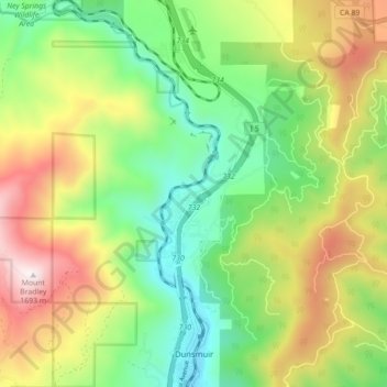
Naam: Topografische kaart Dunsmuir, hoogte, reliëf.
Gemiddelde hoogte: 1.075 m
Minimale hoogte: 688 m
Maximale hoogte: 1.674 m
At an elevation of approximately 2,350 feet (720 m) above sea level, a unique setting is created by the Sacramento River in which class 3 whitewater rapids are usually created during summer run off through a town of about 2,000 residents. In plain view from some of the city's public streets, this may be one of the few places in western North America where three categories of "twos" (population, elevation, and whitewater difficulty) are met or eclipsed. (Eastern US example-The Cherry River at Richwood, WV)
Andere topografische kaarten
Klik op een kaart om zijn topografie, zijn hoogte en zijn reliëf te bekijken.
Weed
United States > California > Siskiyou County
Weed, Siskiyou County, California, 96094, United States
Gemiddelde hoogte: 1.116 m
Mount Shasta
United States > California > Siskiyou County
Mount Shasta, Siskiyou County, California, United States
Gemiddelde hoogte: 3.717 m
Canyon Mountain
United States > California > Siskiyou County
Canyon Mountain, Siskiyou County, CAL Fire Northern Region, California, United States
Gemiddelde hoogte: 1.026 m
Miller Mountain
United States > California > Siskiyou County
Miller Mountain, Siskiyou County, CAL Fire Northern Region, California, United States
Gemiddelde hoogte: 1.935 m
Salmon Lake
United States > California > Siskiyou County
Salmon Lake, Siskiyou County, CAL Fire Northern Region, California, United States
Gemiddelde hoogte: 2.054 m
Yreka
United States > California > Siskiyou County
Yreka, Siskiyou County, California, 96097, United States
Gemiddelde hoogte: 917 m
Piney Mountain
United States > California > Siskiyou County
Piney Mountain, Siskiyou County, CAL Fire Northern Region, California, United States
Gemiddelde hoogte: 1.099 m
Klamath River
United States > California > Siskiyou County > Klamath River
Klamath River, Siskiyou County, California, 96050, United States
Gemiddelde hoogte: 751 m
Happy Camp
United States > California > Siskiyou County > Happy Camp
Happy Camp, Siskiyou County, California, United States
Gemiddelde hoogte: 470 m
Gazelle
United States > California > Siskiyou County
Gazelle, Siskiyou County, California, United States
Gemiddelde hoogte: 861 m
Hornbrook
United States > California > Siskiyou County
Hornbrook, Siskiyou County, CAL Fire Northern Region, California, United States
Gemiddelde hoogte: 704 m
Tulelake
United States > California > Siskiyou County
Tulelake, Siskiyou County, CAL Fire Northern Region, California, United States
Gemiddelde hoogte: 1.230 m