
Topografische kaart Mount Shasta
Interactieve kaart
Klik op de kaart om de hoogte weer te geven.
Over deze kaart
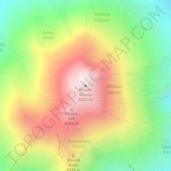
Naam: Topografische kaart Mount Shasta, hoogte, reliëf.
Locatie: Mount Shasta, Siskiyou County, California, United States (41.40915 -122.19491 41.40925 -122.19481)
Gemiddelde hoogte: 3.717 m
Minimale hoogte: 3.194 m
Maximale hoogte: 4.309 m
Mount Shasta (/ˈʃæstə/ SHASS-tə; Shasta: Waka-nunee-Tuki-wuki; Karuk: Úytaahkoo) is a potentially active volcano at the southern end of the Cascade Range in Siskiyou County, California. At an elevation of 14,179 feet (4,321.8 meters), it is the second-highest peak in the Cascades and the fifth-highest in the state. Mount Shasta has an estimated volume of 85 cubic miles (350 cubic kilometers), which makes it the most voluminous stratovolcano in the Cascade Volcanic Arc. The mountain and surrounding area are part of the Shasta–Trinity National Forest.
Andere topografische kaarten
Klik op een kaart om zijn topografie, zijn hoogte en zijn reliëf te bekijken.
Weed
United States > California > Siskiyou County
Weed, Siskiyou County, California, 96094, United States
Gemiddelde hoogte: 1.116 m
Canyon Mountain
United States > California > Siskiyou County
Canyon Mountain, Siskiyou County, CAL Fire Northern Region, California, United States
Gemiddelde hoogte: 1.026 m
Miller Mountain
United States > California > Siskiyou County
Miller Mountain, Siskiyou County, CAL Fire Northern Region, California, United States
Gemiddelde hoogte: 1.935 m
Salmon Lake
United States > California > Siskiyou County
Salmon Lake, Siskiyou County, CAL Fire Northern Region, California, United States
Gemiddelde hoogte: 2.054 m
Yreka
United States > California > Siskiyou County
Yreka, Siskiyou County, California, 96097, United States
Gemiddelde hoogte: 917 m
Piney Mountain
United States > California > Siskiyou County
Piney Mountain, Siskiyou County, CAL Fire Northern Region, California, United States
Gemiddelde hoogte: 1.099 m
Klamath River
United States > California > Siskiyou County > Klamath River
Klamath River, Siskiyou County, California, 96050, United States
Gemiddelde hoogte: 751 m
Happy Camp
United States > California > Siskiyou County > Happy Camp
Happy Camp, Siskiyou County, California, United States
Gemiddelde hoogte: 470 m
Dunsmuir
United States > California > Siskiyou County
Dunsmuir, Siskiyou County, California, 96025, United States
Gemiddelde hoogte: 1.075 m
Gazelle
United States > California > Siskiyou County
Gazelle, Siskiyou County, California, United States
Gemiddelde hoogte: 861 m
Hornbrook
United States > California > Siskiyou County
Hornbrook, Siskiyou County, CAL Fire Northern Region, California, United States
Gemiddelde hoogte: 704 m
Tulelake
United States > California > Siskiyou County
Tulelake, Siskiyou County, CAL Fire Northern Region, California, United States
Gemiddelde hoogte: 1.230 m