
Topografische kaart Angul District
Interactieve kaart
Klik op de kaart om de hoogte weer te geven.
Over deze kaart
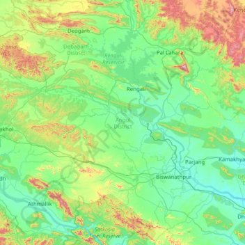
Naam: Topografische kaart Angul District, hoogte, reliëf.
Locatie: Angul District, Odisha, India (20.52806 84.26205 21.68017 85.39269)
Gemiddelde hoogte: 234 m
Minimale hoogte: 37 m
Maximale hoogte: 1.161 m
Angul is located in the centre of the state of Odisha and lies between the latitudes of 20°31′N and 21°40′N and longitudes of 84°15′E and 85°23′E. The altitude is between 564 and 1,187 metres (1,850 and 3,894 ft). The district has an area of 6,232 km2 (2,406 sq mi). It is bounded by Dhenkanal and Cuttack district in the east, Deogarh, Kendujhar and Sundargarh district in north, Sambalpur and Sonepur in west and Boudh and Nayagarh in the south side. The district is abundant with natural resources. Angul, The district headquarters is about 150 kilometres (93 mi) from the state capital Bhubaneswar.
Andere topografische kaarten
Klik op een kaart om zijn topografie, zijn hoogte en zijn reliëf te bekijken.
Cuttack
India > Odisha > Cuttack (M.Corp.) P.S
Cuttack, Cuttack (M.Corp.) P.S, Cuttack, Odisha, 753001, India
Gemiddelde hoogte: 34 m
Ward 43
India > Odisha > Bhubaneswar (M.Corp.) > Bhubaneswar Municipal Corporation
Ward 43, South East Zone, Bhubaneswar Municipal Corporation, Bhubaneswar (M.Corp.), Khordha District, Odisha, India
Gemiddelde hoogte: 28 m
Barabati
India > Odisha > Dharmasala
Barabati, Dharmasala, Jajpur District, Odisha, 755008, India
Gemiddelde hoogte: 17 m
Subarnapur
Subarnapur, Sonapur, Subarnapur District, Odisha, 767017, India
Gemiddelde hoogte: 112 m
Rushikulya
India > Odisha > Purusottampur
Rushikulya, Purusottampur, Ganjam District, Odisha, India
Gemiddelde hoogte: 32 m
Vamsadhara
India > Odisha > Gudari > Gudari
Vamsadhara, Gudari, Rayagada District, Odisha, 765026, India
Gemiddelde hoogte: 304 m
Brahmapur (M.Corp.)
Brahmapur (M.Corp.), Ganjam District, Odisha, India
Gemiddelde hoogte: 22 m
Ward 44
India > Odisha > Bhubaneswar (M.Corp.) > Bhubaneswar Municipal Corporation
Ward 44, South East Zone, Bhubaneswar Municipal Corporation, Bhubaneswar (M.Corp.), Khordha District, Odisha, India
Gemiddelde hoogte: 21 m
Kusumi
India > Odisha > Mahulpalli
Kusumi, Mahulpalli, Sambalpur District, Odisha, India
Gemiddelde hoogte: 270 m
Boudh
India > Odisha > Baudh Sadar
Boudh, Baudh Sadar, Boudh District, Odisha, 762014, India
Gemiddelde hoogte: 93 m
Kendujhargarh
India > Odisha > Kendujhar Town
Kendujhargarh, Kendujhar Town, Kendujhar District, Odisha, 758001, India
Gemiddelde hoogte: 481 m
Paradeep Lock
Paradeep Lock, Jagatsinghapur District, Odisha, India
Gemiddelde hoogte: 3 m
Biramitrapur
India > Odisha > Biramitrapur
Biramitrapur, Sundargarh District, Odisha, 770033, India
Gemiddelde hoogte: 285 m
Brahmani River
Brahmani River, Rajnagar, Kendrapara District, Odisha, India
Gemiddelde hoogte: 3 m
Narayanpatana
Narayanpatana, Koraput District, Odisha, 764014, India
Gemiddelde hoogte: 677 m
KAIPADAR
India > Odisha > Khordha Sadar
KAIPADAR, Khordha Sadar, Khordha District, Odisha, 752056, India
Gemiddelde hoogte: 62 m