
Topografische kaart Dodge County
Interactieve kaart
Klik op de kaart om de hoogte weer te geven.
Over deze kaart
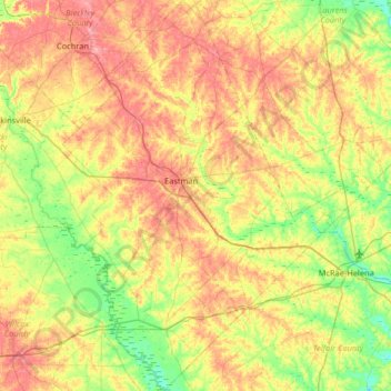
Naam: Topografische kaart Dodge County, hoogte, reliëf.
Locatie: Dodge County, Georgia, United States (31.90071 -83.37412 32.45243 -82.85804)
Gemiddelde hoogte: 84 m
Minimale hoogte: 40 m
Maximale hoogte: 141 m
The Heart of Georgia Regional Airport is located three miles east of Eastman off of State Route 46. Elevation 304'. Runway 02/20 is 6,506'x100'and has a precision instrument landing system. The airport is owned by the Heart of Georgia Regional Airport Authority and is home to the Middle Georgia State College Georgia Aviation campus. Middle Georgia State College operates the Federal Aviation Administration's #1 ranked student control tower in the United States. Other businesses at the airport include aircraft manufacturing, aircraft metal finishing, and general metal fabrication. The airport's fixed-base operator is located in the terminal building midfield. The terminal building is named after W. S. Stuckey Sr., founder of Stuckey's Candy Company (now Standard Candy) an aviation pioneer who is from Eastman.
Andere topografische kaarten
Klik op een kaart om zijn topografie, zijn hoogte en zijn reliëf te bekijken.
Atkinson County
Atkinson County, Georgia, 31642, United States
Gemiddelde hoogte: 62 m
Metter
United States > Georgia > Candler County
Metter, Candler County, Georgia, 30439, United States
Gemiddelde hoogte: 62 m
Marion
United States > Georgia > Twiggs County
Marion, Twiggs County, Georgia, United States
Gemiddelde hoogte: 115 m
The Lakes
United States > Georgia > Camden County > Kingsland
The Lakes, Kingsland, Camden County, Georgia, 31548, United States
Gemiddelde hoogte: 7 m
Orchard Hill
United States > Georgia > Spalding County
Orchard Hill, Spalding County, Georgia, United States
Gemiddelde hoogte: 253 m
Valdosta
United States > Georgia > Lowndes County
Valdosta, Lowndes County, Georgia, United States
Gemiddelde hoogte: 58 m
South Fulton
United States > Georgia > Fulton County
South Fulton, Fulton County, Georgia, United States
Gemiddelde hoogte: 272 m
Gwinnett County
Gwinnett County, Georgia, United States
Gemiddelde hoogte: 302 m
Taylor Lake Dam South
United States > Georgia > Calhoun County
Taylor Lake Dam South, Calhoun County, Georgia, 39866, United States
Gemiddelde hoogte: 68 m
Whitesburg
United States > Georgia > Carroll County
Whitesburg, Carroll County, Georgia, United States
Gemiddelde hoogte: 249 m
Chattahoochee Hills
United States > Georgia > Fulton County
Chattahoochee Hills, Fulton County, Georgia, United States
Gemiddelde hoogte: 261 m
Piney Bluff
United States > Georgia > Camden County
Piney Bluff, Camden County, Georgia, United States
Gemiddelde hoogte: 2 m
Thompson Dam
United States > Georgia > Dooly County
Thompson Dam, Dooly County, Georgia, United States
Gemiddelde hoogte: 123 m
Darien
United States > Georgia > McIntosh County
Darien, McIntosh County, Georgia, 31305, United States
Gemiddelde hoogte: 3 m
Senoia
United States > Georgia > Coweta County
Senoia, Coweta County, Georgia, United States
Gemiddelde hoogte: 248 m
Hiram
United States > Georgia > Paulding County
Hiram, Paulding County, Georgia, United States
Gemiddelde hoogte: 306 m
Nevils
United States > Georgia > Bulloch County
Nevils, Bulloch County, Georgia, United States
Gemiddelde hoogte: 51 m
Douglasville
United States > Georgia > Douglas County
Douglasville, Douglas County, Georgia, 30133, United States
Gemiddelde hoogte: 310 m
Pennant Hill
United States > Georgia > Glynn County
Pennant Hill, Glynn County, Georgia, United States
Gemiddelde hoogte: 5 m
Norman Park
United States > Georgia > Colquitt County
Norman Park, Colquitt County, Georgia, United States
Gemiddelde hoogte: 100 m
Sandy
United States > Georgia > Butts County
Sandy, Butts County, Georgia, 30216, United States
Gemiddelde hoogte: 164 m
Currahee Mountain
United States > Georgia > Stephens County
Currahee Mountain, Stephens County, Georgia, United States
Gemiddelde hoogte: 303 m
Columbus
United States > Georgia > Muscogee County
Columbus, Muscogee County, Georgia, United States
Gemiddelde hoogte: 130 m
Decatur
United States > Georgia > DeKalb County
Decatur, DeKalb County, Georgia, 30030, United States
Gemiddelde hoogte: 308 m
Pine Mountain
United States > Georgia > Harris County
Pine Mountain, Harris County, Georgia, United States
Gemiddelde hoogte: 274 m
Clarkesville
United States > Georgia > Habersham County
Clarkesville, Habersham County, Georgia, United States
Gemiddelde hoogte: 418 m
Atlanta
United States > Georgia > Fulton County
Atlanta, Fulton County, Georgia, 30303, United States
Gemiddelde hoogte: 285 m
Crestwood Estates
United States > Georgia > Athens-Clarke County > Athens-Clarke County Unified Government
Crestwood Estates, Athens-Clarke County Unified Government, Athens-Clarke County, Georgia, 30605, United States
Gemiddelde hoogte: 213 m
Mary Cove
United States > Georgia > Rabun County
Mary Cove, Rabun County, Georgia, United States
Gemiddelde hoogte: 602 m
Nicholson
United States > Georgia > Jackson County
Nicholson, Jackson County, Georgia, United States
Gemiddelde hoogte: 245 m
Morven
United States > Georgia > Brooks County
Morven, Brooks County, Georgia, 31638, United States
Gemiddelde hoogte: 65 m
Brooklet
United States > Georgia > Bulloch County
Brooklet, Bulloch County, Georgia, United States
Gemiddelde hoogte: 49 m
Peachtree City
United States > Georgia > Peachtree City
Peachtree City, Fayette County, Georgia, 30269-3911, United States
Gemiddelde hoogte: 267 m
Hogan
United States > Georgia > Camden County
Hogan, Camden County, Georgia, United States
Gemiddelde hoogte: 3 m
Whitfield County
United States > Georgia > Whitfield County
Whitfield County, Georgia, United States
Gemiddelde hoogte: 258 m
Athens-Clarke County Unified Government
United States > Georgia > Athens-Clarke County > Athens-Clarke County Unified Government
Athens-Clarke County Unified Government, Athens-Clarke County, Georgia, United States
Gemiddelde hoogte: 219 m
Mount Vernon
United States > Georgia > Richmond County > Augusta > Mount Vernon
Mount Vernon, Augusta, Richmond County, Georgia, 30906, United States
Gemiddelde hoogte: 77 m