
Topografische kaart Bihar
Interactieve kaart
Klik op de kaart om de hoogte weer te geven.
Over deze kaart
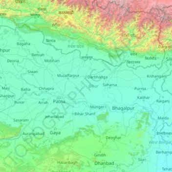
Naam: Topografische kaart Bihar, hoogte, reliëf.
Locatie: Bihar, India (24.28572 83.32126 27.52164 88.29823)
Gemiddelde hoogte: 606 m
Minimale hoogte: 11 m
Maximale hoogte: 8.419 m
Bihar covers a total area of 94,163 km2 (36,357 sq mi), with an average elevation above sea level of 173 feet (53 m). It is land locked by Nepal in the north, Jharkhand in the south West Bengal in the east and Uttar Pradesh to the west. It has three parts on the basis of physical and structural conditions: the Southern Plateau, the Shivalik Region, and Bihar's Gangetic Plain. Furthermore, the vast stretch of fertile Bihar Plain is divided by the Ganges River into two unequal parts – North Bihar and South Bihar. The Ganges flows west–east and, along with its tributaries, regularly floods parts of the Bihar plain. The main northern tributaries are the Gandak and Koshi, which originate in the Nepalese Himalayas, and the Bagmati, which originates in the Kathmandu Valley. Other tributaries are the Son, Budhi Gandak, Chandan, Orhani and Phalgu. Bihar has some small hills, such as the Rajgir hills in center, Kaimur Range in south-west and Shivalik Range in North. Bihar has notified forest area of 6,764.14 km2, which is 7.1 percent of its geographical area. The sub-Himalayan foothills of Shivalik ranges, primary Someshwar and Dun mountain, in West Champaran district are clad in a belt of moist deciduous forest. As well as trees, this consists of scrub, grass and reeds.
Andere topografische kaarten
Klik op een kaart om zijn topografie, zijn hoogte en zijn reliëf te bekijken.
Bengaluru
India > Karnataka > Bangalore North
Bengaluru, Bangalore North, Bengaluru Urban District, Karnataka, India
Gemiddelde hoogte: 881 m
3d
India > Rajasthan > Ganganagar Tehsil > 1 LNP
3d, 1 LNP, Ganganagar Tehsil, Sri Ganganagar District, Rajasthan, India
Gemiddelde hoogte: 178 m
Chennai
India > Tamil Nadu > Chennai
Chennai, Chennai District, Tamil Nadu, India
Gemiddelde hoogte: 8 m
Srinagar
India > Jammu and Kashmir > Srinagar (South)
Srinagar, Srinagar (South), Srinagar District, Jammu and Kashmir, 190001, India
Gemiddelde hoogte: 1.805 m
Mysuru
India > Karnataka > Mysuru taluk
Mysuru, Mysuru taluk, Mysuru District, Karnataka, 570001, India
Gemiddelde hoogte: 727 m
Pune
India > Maharashtra > Pune City > Pune
Pune, Pune City, Pune District, Maharashtra, 411001, India
Gemiddelde hoogte: 641 m
Prayagraj
India > Uttar Pradesh > Prayagraj
Prayagraj, Prayagraj District, Uttar Pradesh, 211001, India
Gemiddelde hoogte: 91 m
Jagdevpur mandal
Jagdevpur mandal, Siddipet District, Telangana, India
Gemiddelde hoogte: 537 m
Suryanelli
India > Kerala > Udumbanchola
Suryanelli, Udumbanchola, Idukki District, Kerala, India
Gemiddelde hoogte: 1.553 m
Bachupally mandal
Bachupally mandal, Medchal–Malkajgiri District, Telangana, 500090, India
Gemiddelde hoogte: 593 m
Murbad
India > Maharashtra > Murbad Taluka > Murbad
Murbad, Murbad Taluka, Thane District, Maharashtra, India
Gemiddelde hoogte: 91 m
Kolkata
Kolkata, Kolkata District, West Bengal, 700073, India
Gemiddelde hoogte: 5 m
Kodangal
India > Telangana > Kodangal mandal
Kodangal, Kodangal mandal, Vikarabad District, Telangana, 509338, India
Gemiddelde hoogte: 553 m
Whitefield
India > Karnataka > Bangalore East > Bengaluru
Whitefield, Bengaluru, Bangalore East, Bengaluru Urban District, Karnataka, 560066, India
Gemiddelde hoogte: 875 m
Gurgaon
India > Haryana > Gurugram District
Gurgaon, Gurugram District, Haryana, India
Gemiddelde hoogte: 237 m
Kodaikanal
Kodaikanal, Dindigul District, Tamil Nadu, India
Gemiddelde hoogte: 869 m
Vijayawada
India > Andhra Pradesh > Vijayawada (Urban)
Vijayawada, Vijayawada (Urban), NTR District, Andhra Pradesh, 520001, India
Gemiddelde hoogte: 36 m
Jaipur
India > Rajasthan > Jaipur Tehsil
Jaipur, Jaipur Municipal Corporation, Jaipur Tehsil, Jaipur District, Rajasthan, 302001, India
Gemiddelde hoogte: 408 m
Sultanpur Lodhi
India > Punjab > Sultanpur Lodhi Tahsil
Sultanpur Lodhi, Sultanpur Lodhi Tahsil, Kapurthala District, Punjab, 144626, India
Gemiddelde hoogte: 214 m
Banjar
India > Himachal Pradesh > Bhuntar
Banjar, Bhuntar, Kullu District, Himachal Pradesh, 175125, India
Gemiddelde hoogte: 1.271 m