
Topografische kaart Wahwashkesh Lake
Interactieve kaart
Klik op de kaart om de hoogte weer te geven.
Over deze kaart
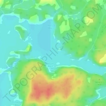
Naam: Topografische kaart Wahwashkesh Lake, hoogte, reliëf.
Gemiddelde hoogte: 237 m
Minimale hoogte: 220 m
Maximale hoogte: 266 m
Andere topografische kaarten
Klik op een kaart om zijn topografie, zijn hoogte en zijn reliëf te bekijken.
Whitestone
Canada > Ontario > Parry Sound District > Whitestone
Whitestone, Parry Sound District, Central Ontario, Ontario, P0A 1G0, Canada
Gemiddelde hoogte: 249 m
Wahwashkesh
Canada > Ontario > Parry Sound District > Whitestone
Wahwashkesh, Whitestone, Parry Sound District, Central Ontario, Ontario, Canada
Gemiddelde hoogte: 230 m
Whitestone Lake
Canada > Ontario > Parry Sound District > Whitestone > Dunchurch
Whitestone Lake, Dunchurch, Whitestone, Parry Sound District, Central Ontario, Ontario, Canada
Gemiddelde hoogte: 269 m
Bolger Lake
Canada > Ontario > Parry Sound District > Whitestone
Bolger Lake, Whitestone, Parry Sound District, Central Ontario, Ontario, Canada
Gemiddelde hoogte: 237 m
Lorimer Lake
Canada > Ontario > Parry Sound District > Whitestone
Lorimer Lake, Whitestone, Parry Sound District, Central Ontario, Ontario, Canada
Gemiddelde hoogte: 256 m
Shanty Bay
Canada > Ontario > Parry Sound District > Whitestone
Shanty Bay, Whitestone, Parry Sound District, Central Ontario, Ontario, Canada
Gemiddelde hoogte: 232 m