
Doe een donatie
Rust jezelf uit voor je volgende avontuur:
Als Amazon-partner verdient deze site een commissie op in aanmerking komende aankopen, zonder extra kosten voor jou.
Topografische kaart Whitestone
Klik op de kaart om de hoogte weer te geven.
Doe een donatie
Rust jezelf uit voor je volgende avontuur:
Als Amazon-partner verdient deze site een commissie op in aanmerking komende aankopen, zonder extra kosten voor jou.
Over deze kaart
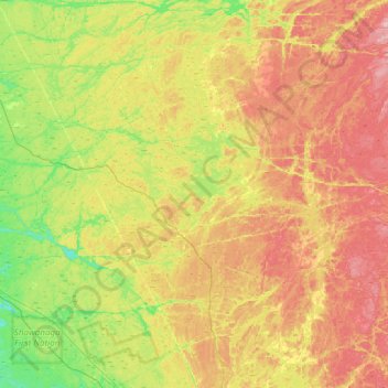
Naam: Topografische kaart Whitestone, hoogte, reliëf.
Gemiddelde hoogte: 249 m
Minimale hoogte: 177 m
Maximale hoogte: 341 m
Doe een donatie
Rust jezelf uit voor je volgende avontuur:
Als Amazon-partner verdient deze site een commissie op in aanmerking komende aankopen, zonder extra kosten voor jou.
Andere topografische kaarten
Klik op een kaart om zijn topografie, zijn hoogte en zijn reliëf te bekijken.
Lake Bernard
Canada > Ontario > Parry Sound District > Strong Township > Sundridge
Gemiddelde hoogte: 347 m
Moon River
Canada > Ontario > Parry Sound District > The Archipelago Township
Gemiddelde hoogte: 185 m
Doe een donatie
Rust jezelf uit voor je volgende avontuur:
Als Amazon-partner verdient deze site een commissie op in aanmerking komende aankopen, zonder extra kosten voor jou.
Pickerel River
Canada > Ontario > Parry Sound District > Unorganized Centre Parry Sound
Gemiddelde hoogte: 200 m
Dokis Island
Canada > Ontario > Parry Sound District > Unorganized Centre Parry Sound
Gemiddelde hoogte: 196 m
Port Loring
Canada > Ontario > Parry Sound District > Unorganized Centre Parry Sound
Gemiddelde hoogte: 227 m
Restoule
Canada > Ontario > Parry Sound District > Unorganized Centre Parry Sound
Gemiddelde hoogte: 237 m
Doe een donatie
Rust jezelf uit voor je volgende avontuur:
Als Amazon-partner verdient deze site een commissie op in aanmerking komende aankopen, zonder extra kosten voor jou.
Pointe au Baril
Canada > Ontario > Parry Sound District > The Archipelago Township
Gemiddelde hoogte: 177 m
Dollars Lake
Canada > Ontario > Parry Sound District > Unorganized Centre Parry Sound
Gemiddelde hoogte: 215 m
Doe een donatie
Rust jezelf uit voor je volgende avontuur:
Als Amazon-partner verdient deze site een commissie op in aanmerking komende aankopen, zonder extra kosten voor jou.
Diamond Lake
Canada > Ontario > Parry Sound District > Seguin Township > Orrville
Gemiddelde hoogte: 273 m
Doe een donatie
Rust jezelf uit voor je volgende avontuur:
Als Amazon-partner verdient deze site een commissie op in aanmerking komende aankopen, zonder extra kosten voor jou.
Stormy Lake
Canada > Ontario > Parry Sound District > Unorganized Centre Parry Sound
Gemiddelde hoogte: 227 m
Doe een donatie
Rust jezelf uit voor je volgende avontuur:
Als Amazon-partner verdient deze site een commissie op in aanmerking komende aankopen, zonder extra kosten voor jou.
Arnstein
Canada > Ontario > Parry Sound District > Unorganized Centre Parry Sound
Gemiddelde hoogte: 233 m
Doe een donatie
Rust jezelf uit voor je volgende avontuur:
Als Amazon-partner verdient deze site een commissie op in aanmerking komende aankopen, zonder extra kosten voor jou.
Ferguson Island
Canada > Ontario > Parry Sound District > Unorganized Centre Parry Sound
Gemiddelde hoogte: 206 m
Manitouwabing Lake
Canada > Ontario > Parry Sound District > McKellar Township > McKellar
Gemiddelde hoogte: 249 m
Whistler Bay
Canada > Ontario > Parry Sound District > Unorganized Centre Parry Sound
Gemiddelde hoogte: 178 m
Doe een donatie
Rust jezelf uit voor je volgende avontuur:
Als Amazon-partner verdient deze site een commissie op in aanmerking komende aankopen, zonder extra kosten voor jou.
Orrville
Canada > Ontario > Parry Sound District > Seguin Township > Orrville
Gemiddelde hoogte: 262 m
Magnetawan River
Canada > Ontario > Parry Sound District > Unorganized Centre Parry Sound
Gemiddelde hoogte: 198 m
Doe een donatie
Rust jezelf uit voor je volgende avontuur:
Als Amazon-partner verdient deze site een commissie op in aanmerking komende aankopen, zonder extra kosten voor jou.
Cole Lake
Canada > Ontario > Parry Sound District > Unorganized Centre Parry Sound
Gemiddelde hoogte: 216 m
Conger Lake
Canada > Ontario > Parry Sound District > The Archipelago Township
Gemiddelde hoogte: 200 m
Doe een donatie
Rust jezelf uit voor je volgende avontuur:
Als Amazon-partner verdient deze site een commissie op in aanmerking komende aankopen, zonder extra kosten voor jou.
Deer Horn Island
Canada > Ontario > Parry Sound District > The Archipelago Township
Gemiddelde hoogte: 199 m
Richardson Island
Canada > Ontario > Parry Sound District > Nipissing Township
Gemiddelde hoogte: 194 m
Key River
Canada > Ontario > Parry Sound District > Unorganized Centre Parry Sound
Gemiddelde hoogte: 194 m
Doe een donatie
Rust jezelf uit voor je volgende avontuur:
Als Amazon-partner verdient deze site een commissie op in aanmerking komende aankopen, zonder extra kosten voor jou.
Bosworth Island
Canada > Ontario > Parry Sound District > Unorganized Centre Parry Sound
Gemiddelde hoogte: 224 m
Doe Lake
Canada > Ontario > Parry Sound District > McMurrich/Monteith Township
Gemiddelde hoogte: 303 m
Doe een donatie
Rust jezelf uit voor je volgende avontuur:
Als Amazon-partner verdient deze site een commissie op in aanmerking komende aankopen, zonder extra kosten voor jou.
Culin Lake
Canada > Ontario > Parry Sound District > Unorganized Centre Parry Sound > Arnstein
Gemiddelde hoogte: 230 m
Bob's Lake
Canada > Ontario > Parry Sound District > Unorganized Centre Parry Sound
Gemiddelde hoogte: 255 m
Doe een donatie
Rust jezelf uit voor je volgende avontuur:
Als Amazon-partner verdient deze site een commissie op in aanmerking komende aankopen, zonder extra kosten voor jou.
Memesagamesing Lake Dam
Canada > Ontario > Parry Sound District > Unorganized Centre Parry Sound
Gemiddelde hoogte: 227 m
Doe een donatie
Rust jezelf uit voor je volgende avontuur:
Als Amazon-partner verdient deze site een commissie op in aanmerking komende aankopen, zonder extra kosten voor jou.
Dollars Lake
Canada > Ontario > Parry Sound District > Unorganized Centre Parry Sound
Gemiddelde hoogte: 215 m
Jack's Ridge
Canada > Ontario > Parry Sound District > Unorganized Centre Parry Sound
Gemiddelde hoogte: 254 m
Doe een donatie
Rust jezelf uit voor je volgende avontuur:
Als Amazon-partner verdient deze site een commissie op in aanmerking komende aankopen, zonder extra kosten voor jou.
Oastler Lake Provincial Park
Canada > Ontario > Parry Sound District > Seguin Township
Gemiddelde hoogte: 218 m
Doe een donatie
Rust jezelf uit voor je volgende avontuur:
Als Amazon-partner verdient deze site een commissie op in aanmerking komende aankopen, zonder extra kosten voor jou.
Key River
Canada > Ontario > Parry Sound District > Unorganized Centre Parry Sound
Gemiddelde hoogte: 193 m
Smith Bay
Canada > Ontario > Parry Sound District > Unorganized Centre Parry Sound
Gemiddelde hoogte: 217 m
Doe een donatie
Rust jezelf uit voor je volgende avontuur:
Als Amazon-partner verdient deze site een commissie op in aanmerking komende aankopen, zonder extra kosten voor jou.
Sundridge
Canada > Ontario > Parry Sound District > Strong Township > Sundridge
Gemiddelde hoogte: 355 m
Moon River
Canada > Ontario > Parry Sound District > The Archipelago Township
Gemiddelde hoogte: 185 m
Doe een donatie
Rust jezelf uit voor je volgende avontuur:
Als Amazon-partner verdient deze site een commissie op in aanmerking komende aankopen, zonder extra kosten voor jou.
Watt Island
Canada > Ontario > Parry Sound District > The Archipelago Township
Gemiddelde hoogte: 195 m
Nipissing
Canada > Ontario > Parry Sound District > Nipissing Township > Nipissing
Gemiddelde hoogte: 227 m
Doe een donatie
Rust jezelf uit voor je volgende avontuur:
Als Amazon-partner verdient deze site een commissie op in aanmerking komende aankopen, zonder extra kosten voor jou.
Recollet Falls
Canada > Ontario > Parry Sound District > Unorganized Centre Parry Sound
Gemiddelde hoogte: 206 m
Doe een donatie
Rust jezelf uit voor je volgende avontuur:
Als Amazon-partner verdient deze site een commissie op in aanmerking komende aankopen, zonder extra kosten voor jou.
Loring
Canada > Ontario > Parry Sound District > Unorganized Centre Parry Sound
Gemiddelde hoogte: 241 m
Doe een donatie
Rust jezelf uit voor je volgende avontuur:
Als Amazon-partner verdient deze site een commissie op in aanmerking komende aankopen, zonder extra kosten voor jou.
Key Harbour
Canada > Ontario > Parry Sound District > Unorganized Centre Parry Sound
Gemiddelde hoogte: 178 m
Clear Lake
Canada > Ontario > Parry Sound District > Unorganized Centre Parry Sound
Gemiddelde hoogte: 222 m
Skye Island
Canada > Ontario > Parry Sound District > The Archipelago Township
Gemiddelde hoogte: 191 m
Doe een donatie
Rust jezelf uit voor je volgende avontuur:
Als Amazon-partner verdient deze site een commissie op in aanmerking komende aankopen, zonder extra kosten voor jou.
Magee Island
Canada > Ontario > Parry Sound District > Unorganized Centre Parry Sound
Gemiddelde hoogte: 196 m
Doe een donatie
Rust jezelf uit voor je volgende avontuur:
Als Amazon-partner verdient deze site een commissie op in aanmerking komende aankopen, zonder extra kosten voor jou.
Sprucedale
Canada > Ontario > Parry Sound District > McMurrich/Monteith Township
Gemiddelde hoogte: 330 m
Jack's Ridge
Canada > Ontario > Parry Sound District > Unorganized Centre Parry Sound
Gemiddelde hoogte: 254 m
Doe een donatie
Rust jezelf uit voor je volgende avontuur:
Als Amazon-partner verdient deze site een commissie op in aanmerking komende aankopen, zonder extra kosten voor jou.
Jack's Ridge
Canada > Ontario > Parry Sound District > Unorganized Centre Parry Sound
Gemiddelde hoogte: 254 m