Geolokaliseren

Topografische kaart Khangchendzonga National Park

Interactieve kaart

Klik op de kaart om de hoogte weer te geven.

Over deze kaart

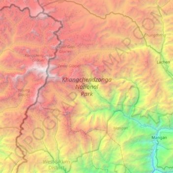
Naam: Topografische kaart Khangchendzonga National Park, hoogte, reliëf.

Locatie: Khangchendzonga National Park, North Sikkim Highway, Mangan, North Sikkim District, Sikkim, India (27.39267 88.04354 27.91868 88.62545)

Gemiddelde hoogte: 4.330 m

Minimale hoogte: 599 m

Maximale hoogte: 8.521 m

The Kanchenjunga Park is situated in the North and West Sikkim districts in the Indian state of Sikkim. It has an elevation of 1,829 metres (6,001 ft) to over 8,550 metres (28,050 ft) and has an area of 849.50 km2 (327.99 sq mi). It is one of the few high-altitude National parks of India and was recently included as a mixed-criteria UNESCO World Heritage site.

Andere topografische kaarten

Klik op een kaart om zijn topografie, zijn hoogte en zijn reliëf te bekijken.

Danfebir

India > Sikkim > Gyalshing

Danfebir, Gyalshing, Gyalshing District, Sikkim, India

Gemiddelde hoogte: 4.330 m

Gangtok

India > Sikkim > Gangtok > Gangtok

Gangtok, East Sikkim District, Sikkim, 737101, India

Gemiddelde hoogte: 1.911 m

Kupup

India > Sikkim

Kupup, Gangtok district, Sikkim, India

Gemiddelde hoogte: 4.007 m

East Sikkim District

India > Sikkim > Pakyong subdivision

East Sikkim District, Pakyong subdivision, Pakyong district, Sikkim, India

Gemiddelde hoogte: 2.107 m

Gyalshing

India > Sikkim

Gyalshing, West Sikkim District, Sikkim, India

Gemiddelde hoogte: 3.139 m

West District

India > Sikkim

West District, West Sikkim District, Sikkim, 737111, India

Gemiddelde hoogte: 2.636 m

Lachung

India > Sikkim > Chungthang

Lachung, Chungthang, Mangan District, Sikkim, India

Gemiddelde hoogte: 3.617 m

Gangtok district

India > Sikkim

Gangtok district, Sikkim, India

Gemiddelde hoogte: 2.334 m

Mangan

India > Sikkim

Mangan, Mangan District, Sikkim, India

Gemiddelde hoogte: 3.312 m

East District

India > Sikkim > East District

East District, East Sikkim District, Sikkim, India

Gemiddelde hoogte: 2.740 m

Soreng

India > Sikkim

Soreng, Soreng District, Sikkim, India

Gemiddelde hoogte: 1.620 m

Pelling

India > Sikkim > Gyalshing > Pelling

Pelling, Gyalshing, West Sikkim District, Sikkim, 737113, India

Gemiddelde hoogte: 1.552 m

Zemu Glacier

India > Sikkim

Zemu Glacier, North District, North Sikkim District, Sikkim, India

Gemiddelde hoogte: 5.499 m

Jorethang

India > Sikkim > Namchi > Jorethang

Jorethang, Namchi, South Sikkim District, Sikkim, India

Gemiddelde hoogte: 723 m

Namchi

India > Sikkim

Namchi, Namchi District, Sikkim, India

Gemiddelde hoogte: 1.040 m

Rumtek

India > Sikkim > Rumtek

Rumtek, Gangtok, East Sikkim District, Sikkim, 737102, India

Gemiddelde hoogte: 1.374 m

Ravangla

India > Sikkim > Ravong

Ravangla, Ravong, Namchi District, Sikkim, 737139, India

Gemiddelde hoogte: 1.870 m

South District

India > Sikkim

South District, South Sikkim District, Sikkim, India

Gemiddelde hoogte: 2.676 m

North District

India > Sikkim

North District, North Sikkim District, Sikkim, India

Gemiddelde hoogte: 3.760 m