
Topografische kaart Pine
Interactieve kaart
Klik op de kaart om de hoogte weer te geven.
Over deze kaart
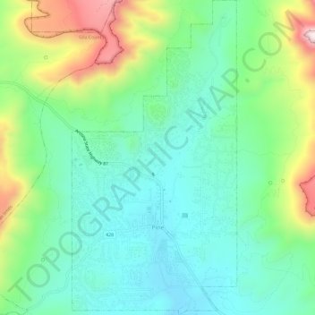
Naam: Topografische kaart Pine, hoogte, reliëf.
Locatie: Pine, Gila County, Arizona, 85544, United States (34.37097 -111.47143 34.41879 -111.44099)
Gemiddelde hoogte: 1.794 m
Minimale hoogte: 1.613 m
Maximale hoogte: 2.221 m
Pine and the adjacent community of Strawberry are rapidly growing vacation and retirement centers in north-central Arizona, below the Mogollon Rim. Pine's elevation is 5,448 feet (1,661 m), and the Pine post office was established in 1884.
Andere topografische kaarten
Klik op een kaart om zijn topografie, zijn hoogte en zijn reliëf te bekijken.
Payson
United States > Arizona > Gila County
Payson, Gila County, Arizona, 85072, United States
Gemiddelde hoogte: 1.522 m
White Tank
United States > Arizona > Gila County
White Tank, Gila County, Arizona, United States
Gemiddelde hoogte: 1.298 m
White Mountain
United States > Arizona > Gila County
White Mountain, Gila County, Arizona, United States
Gemiddelde hoogte: 1.363 m
Miami
United States > Arizona > Gila County
Miami, Gila County, Arizona, 85539, United States
Gemiddelde hoogte: 1.121 m
Globe
United States > Arizona > Gila County
Globe, Gila County, Arizona, 85532, United States
Gemiddelde hoogte: 1.173 m
Cypress Hill
United States > Arizona > Gila County > Star Valley
Cypress Hill, Star Valley, Gila County, Arizona, United States
Gemiddelde hoogte: 1.440 m
Cedar Mesa
United States > Arizona > Gila County
Cedar Mesa, Gila County, Arizona, United States
Gemiddelde hoogte: 1.638 m
Star Valley
United States > Arizona > Gila County > Star Valley
Star Valley, Gila County, Arizona, United States
Gemiddelde hoogte: 1.521 m