
Topografische kaart Payson
Interactieve kaart
Klik op de kaart om de hoogte weer te geven.
Over deze kaart
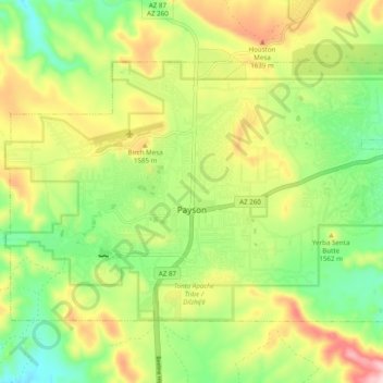
Naam: Topografische kaart Payson, hoogte, reliëf.
Locatie: Payson, Gila County, Arizona, 85072, United States (34.21706 -111.37054 34.27176 -111.27319)
Gemiddelde hoogte: 1.522 m
Minimale hoogte: 1.379 m
Maximale hoogte: 1.725 m
Located in northern Gila County at an elevation of 5,000 feet (1,500 m), the town has a total area of 19.5 square miles (51 km2). The Mogollon Rim, the southern boundary of the Colorado Plateau, lies to the north of Payson, with elevations exceeding 7,500 feet (2,300 m); there are many cold water lakes on top of the rim. They are stocked with fish by the Arizona Game and Fish Department.
Andere topografische kaarten
Klik op een kaart om zijn topografie, zijn hoogte en zijn reliëf te bekijken.
White Tank
United States > Arizona > Gila County
White Tank, Gila County, Arizona, United States
Gemiddelde hoogte: 1.298 m
White Mountain
United States > Arizona > Gila County
White Mountain, Gila County, Arizona, United States
Gemiddelde hoogte: 1.363 m
Pine
United States > Arizona > Gila County
Pine, Gila County, Arizona, 85544, United States
Gemiddelde hoogte: 1.794 m
Miami
United States > Arizona > Gila County
Miami, Gila County, Arizona, 85539, United States
Gemiddelde hoogte: 1.121 m
Globe
United States > Arizona > Gila County
Globe, Gila County, Arizona, 85532, United States
Gemiddelde hoogte: 1.173 m
Cypress Hill
United States > Arizona > Gila County > Star Valley
Cypress Hill, Star Valley, Gila County, Arizona, United States
Gemiddelde hoogte: 1.440 m
Cedar Mesa
United States > Arizona > Gila County
Cedar Mesa, Gila County, Arizona, United States
Gemiddelde hoogte: 1.638 m
Star Valley
United States > Arizona > Gila County > Star Valley
Star Valley, Gila County, Arizona, United States
Gemiddelde hoogte: 1.521 m