
Topografische kaart White Tank
Interactieve kaart
Klik op de kaart om de hoogte weer te geven.
Over deze kaart
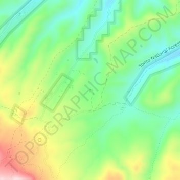
Naam: Topografische kaart White Tank, hoogte, reliëf.
Locatie: White Tank, Gila County, Arizona, United States (33.33730 -110.79446 33.33796 -110.79412)
Gemiddelde hoogte: 1.298 m
Minimale hoogte: 1.195 m
Maximale hoogte: 1.471 m
Andere topografische kaarten
Klik op een kaart om zijn topografie, zijn hoogte en zijn reliëf te bekijken.
Payson
United States > Arizona > Gila County
Payson, Gila County, Arizona, 85072, United States
Gemiddelde hoogte: 1.522 m
White Mountain
United States > Arizona > Gila County
White Mountain, Gila County, Arizona, United States
Gemiddelde hoogte: 1.363 m
Pine
United States > Arizona > Gila County
Pine, Gila County, Arizona, 85544, United States
Gemiddelde hoogte: 1.794 m
Miami
United States > Arizona > Gila County
Miami, Gila County, Arizona, 85539, United States
Gemiddelde hoogte: 1.121 m
Globe
United States > Arizona > Gila County
Globe, Gila County, Arizona, 85532, United States
Gemiddelde hoogte: 1.173 m
Cypress Hill
United States > Arizona > Gila County > Star Valley
Cypress Hill, Star Valley, Gila County, Arizona, United States
Gemiddelde hoogte: 1.440 m
Cedar Mesa
United States > Arizona > Gila County
Cedar Mesa, Gila County, Arizona, United States
Gemiddelde hoogte: 1.638 m
Star Valley
United States > Arizona > Gila County > Star Valley
Star Valley, Gila County, Arizona, United States
Gemiddelde hoogte: 1.521 m