
Topografische kaart Paulding County
Interactieve kaart
Klik op de kaart om de hoogte weer te geven.
Over deze kaart
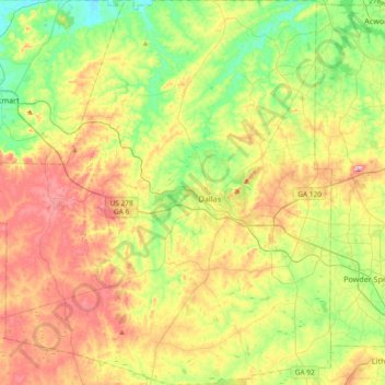
Naam: Topografische kaart Paulding County, hoogte, reliëf.
Locatie: Paulding County, Georgia, United States (33.77476 -85.05031 34.08261 -84.72324)
Gemiddelde hoogte: 311 m
Minimale hoogte: 211 m
Maximale hoogte: 452 m
The county is mainly located in the Piedmont region of the state, with a few mountains located in the county that exceed elevations of 1,000 ft. These mountains are considered to be part of the southernmost extensions of the Appalachian Mountains.
Andere topografische kaarten
Klik op een kaart om zijn topografie, zijn hoogte en zijn reliëf te bekijken.
Atlanta
United States > Georgia > Fulton County
Atlanta, Fulton County, Georgia, United States
Gemiddelde hoogte: 284 m
Athens
United States > Georgia > Athens
Athens, Athens-Clarke County, Georgia, 303341458, United States
Gemiddelde hoogte: 221 m
Tybee Island
United States > Georgia > Chatham County
Tybee Island, Chatham County, Georgia, 31328, United States
Gemiddelde hoogte: 1 m
Savannah
United States > Georgia > Chatham County
Savannah, Chatham County, Georgia, United States
Gemiddelde hoogte: 4 m
Columbus
United States > Georgia > Muscogee County
Columbus, Muscogee County, Georgia, United States
Gemiddelde hoogte: 130 m
Blairsville
United States > Georgia > Union County
Blairsville, Union County, Georgia, United States
Gemiddelde hoogte: 587 m
Blue Ridge
United States > Georgia > Fannin County
Blue Ridge, Fannin County, Georgia, United States
Gemiddelde hoogte: 535 m
Whigham
United States > Georgia > Grady County
Whigham, Grady County, Georgia, United States
Gemiddelde hoogte: 85 m
Atlanta
United States > Georgia > Fulton County
Atlanta, Fulton County, Georgia, 30303, United States
Gemiddelde hoogte: 285 m
Augusta
United States > Georgia > Augusta
Augusta, Richmond County, Georgia, 30901, United States
Gemiddelde hoogte: 90 m
Concord
United States > Georgia > Pike County
Concord, Pike County, Georgia, United States
Gemiddelde hoogte: 249 m
Ellijay
United States > Georgia > Gilmer County
Ellijay, Gilmer County, Georgia, 30540, United States
Gemiddelde hoogte: 424 m
Fort Yargo State Park
United States > Georgia > Barrow County > Winder
Fort Yargo State Park, Winder, Barrow County, Georgia, United States
Gemiddelde hoogte: 270 m
Gwinnett County
Gwinnett County, Georgia, United States
Gemiddelde hoogte: 302 m
Gainesville
United States > Georgia > Hall County
Gainesville, Hall County, Georgia, 30501, United States
Gemiddelde hoogte: 346 m
Saint Simons Island
United States > Georgia > Glynn County
Saint Simons Island, Glynn County, Georgia, 31561, United States
Gemiddelde hoogte: 2 m
Macon
United States > Georgia > Bibb County
Macon, Bibb County, Georgia, United States
Gemiddelde hoogte: 127 m
Radio Springs
United States > Georgia > Floyd County
Radio Springs, Floyd County, Georgia, United States
Gemiddelde hoogte: 243 m
Dahlonega
United States > Georgia > Lumpkin County
Dahlonega, Lumpkin County, Georgia, United States
Gemiddelde hoogte: 411 m
Brunswick
United States > Georgia > Glynn County
Brunswick, Glynn County, Georgia, United States
Gemiddelde hoogte: 2 m
Vinings
United States > Georgia > Cobb County
Vinings, Cobb County, Georgia, 30339, United States
Gemiddelde hoogte: 281 m
Helen
United States > Georgia > White County
Helen, White County, Georgia, 30545, United States
Gemiddelde hoogte: 488 m
Hiawassee
United States > Georgia > Towns County
Hiawassee, Towns County, Georgia, United States
Gemiddelde hoogte: 620 m
Wilscot
United States > Georgia > Fannin County
Wilscot, Fannin County, Georgia, United States
Gemiddelde hoogte: 614 m
Robins Air Force Base
United States > Georgia > Houston County
Robins Air Force Base, Houston County, Georgia, 31098, United States
Gemiddelde hoogte: 92 m
Georgia International Horse Park
United States > Georgia > Rockdale County > Conyers
Georgia International Horse Park, Conyers, Rockdale County, Georgia, United States
Gemiddelde hoogte: 209 m
Alpharetta
United States > Georgia > Fulton County
Alpharetta, Fulton County, Georgia, United States
Gemiddelde hoogte: 324 m
Skidaway Island
United States > Georgia > Chatham County
Skidaway Island, Chatham County, Georgia, 31411, United States
Gemiddelde hoogte: 3 m
Canton
United States > Georgia > Cherokee County
Canton, Cherokee County, Georgia, United States
Gemiddelde hoogte: 320 m
Kennesaw
United States > Georgia > Cobb County
Kennesaw, Cobb County, Georgia, 30144, United States
Gemiddelde hoogte: 317 m
Lumpkin
United States > Georgia > Stewart County
Lumpkin, Stewart County, Georgia, United States
Gemiddelde hoogte: 147 m
Jointer Island
United States > Georgia > Glynn County > Brunswick
Jointer Island, Brunswick, Glynn County, Georgia, United States
Gemiddelde hoogte: 0 m
Heritage Acres
United States > Georgia > Bibb County > Macon
Heritage Acres, Macon, Bibb County, Georgia, 31211, United States
Gemiddelde hoogte: 119 m
Stone Mountain
United States > Georgia > DeKalb County
Stone Mountain, DeKalb County, Georgia, 30087, United States
Gemiddelde hoogte: 299 m
Woodstock
United States > Georgia > Cherokee County
Woodstock, Cherokee County, Georgia, United States
Gemiddelde hoogte: 296 m
Lake Oconee
United States > Georgia > Greene County > Lake Oconee
Lake Oconee, Greene County, Georgia, United States
Gemiddelde hoogte: 165 m
Mountain City
United States > Georgia > Rabun County
Mountain City, Rabun County, Georgia, 30562, United States
Gemiddelde hoogte: 747 m
Iron Mountain
United States > Georgia > Murray County
Iron Mountain, Murray County, Georgia, United States
Gemiddelde hoogte: 362 m
Fort Pulaski
United States > Georgia > Chatham County
Fort Pulaski, Fort Perimeter Trail, Chatham County, Georgia, 31328, United States
Gemiddelde hoogte: 1 m
Tugaloo
United States > Georgia > Habersham County > Tallulah Falls
Tugaloo, Tallulah Falls, Habersham County, Georgia, United States
Gemiddelde hoogte: 392 m