
Topografische kaart Taos County
Interactieve kaart
Klik op de kaart om de hoogte weer te geven.
Over deze kaart
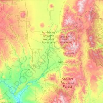
Naam: Topografische kaart Taos County, hoogte, reliëf.
Locatie: Taos County, New Mexico, United States (36.01287 -106.05840 36.99597 -105.20011)
Gemiddelde hoogte: 2.561 m
Minimale hoogte: 1.709 m
Maximale hoogte: 3.980 m
The county's highest point is the summit of Wheeler Peak at 13,161 feet (4,011 m). This is also the highest natural point in New Mexico. The county has the highest mean elevation of any U.S. county outside of Colorado at 8,510 feet (2,590 m), even though it ranks only 22nd overall. Taos County contains 17 of New Mexico's highest 25 peaks.
Andere topografische kaarten
Klik op een kaart om zijn topografie, zijn hoogte en zijn reliëf te bekijken.
Albuquerque
United States > New Mexico > Bernalillo County
Albuquerque, Bernalillo County, New Mexico, United States
Gemiddelde hoogte: 1.688 m
Los Alamos
United States > New Mexico > Los Alamos County
Los Alamos, Los Alamos County, New Mexico, 87544, United States
Gemiddelde hoogte: 2.196 m
Santa Fe
United States > New Mexico > Santa Fe County
Santa Fe, Santa Fe County, New Mexico, United States
Gemiddelde hoogte: 2.221 m
Ruidoso
United States > New Mexico > Lincoln County
Ruidoso, Lincoln County, New Mexico, United States
Gemiddelde hoogte: 2.287 m
Rio Grande
United States > New Mexico > Socorro County
Rio Grande, Socorro County, New Mexico, United States
Gemiddelde hoogte: 1.502 m
Taos
United States > New Mexico > Taos County
Taos, Taos County, New Mexico, United States
Gemiddelde hoogte: 2.180 m
Los Cerrillos
United States > New Mexico > Santa Fe County
Los Cerrillos, Santa Fe County, New Mexico, United States
Gemiddelde hoogte: 1.757 m
Yellow Mountain
United States > New Mexico > Sierra County
Yellow Mountain, Sierra County, New Mexico, United States
Gemiddelde hoogte: 1.647 m
Torreon
United States > New Mexico > Sandoval County
Torreon, Eastern Navajo Agency, Sandoval County, New Mexico, United States
Gemiddelde hoogte: 1.984 m
Tijeras
United States > New Mexico > Bernalillo County
Tijeras, Bernalillo County, New Mexico, 87509, United States
Gemiddelde hoogte: 2.038 m
Miera
United States > New Mexico > Bernalillo County
Miera, Bernalillo County, New Mexico, 87196, United States
Gemiddelde hoogte: 2.232 m
Basin and Range Country Historical Marker
United States > New Mexico > Grant County
Basin and Range Country Historical Marker, Grant County, New Mexico, United States
Gemiddelde hoogte: 1.393 m
Dulce
United States > New Mexico > Rio Arriba County
Dulce, Rio Arriba County, New Mexico, 87528, United States
Gemiddelde hoogte: 2.179 m
Clovis
United States > New Mexico > Curry County
Clovis, Curry County, New Mexico, 88101, United States
Gemiddelde hoogte: 1.317 m
Yankee
United States > New Mexico > Colfax County
Yankee, Colfax County, New Mexico, United States
Gemiddelde hoogte: 2.249 m
South Valley
United States > New Mexico > Bernalillo County
South Valley, Bernalillo County, New Mexico, 87105, United States
Gemiddelde hoogte: 1.519 m
Monte Largo Hills
United States > New Mexico > Bernalillo County > Albuquerque
Monte Largo Hills, Albuquerque, Bernalillo County, New Mexico, 87112, United States
Gemiddelde hoogte: 1.817 m
Tierra Monte
United States > New Mexico > San Miguel County
Tierra Monte, San Miguel County, New Mexico, United States
Gemiddelde hoogte: 2.307 m
White Rock
United States > New Mexico > San Juan County
White Rock, Eastern Navajo Agency, San Juan County, New Mexico, United States
Gemiddelde hoogte: 1.881 m
Sanostee
United States > New Mexico > San Juan County
Sanostee, Shiprock Agency, San Juan County, New Mexico, United States
Gemiddelde hoogte: 1.850 m
Umbrella Rock
United States > New Mexico > McKinley County
Umbrella Rock, Eastern Navajo Agency, McKinley County, New Mexico, United States
Gemiddelde hoogte: 2.168 m
Mayhill
United States > New Mexico > Otero County
Mayhill, Otero County, New Mexico, United States
Gemiddelde hoogte: 2.104 m
Apache Spring
United States > New Mexico > Colfax County > Val Verde Ski Area
Apache Spring, Pam Coleman Drive, Val Verde Ski Area, Colfax County, New Mexico, 87710, United States
Gemiddelde hoogte: 2.966 m
Fairview
United States > New Mexico > Rio Arriba County > Espanola
Fairview, Espanola, Rio Arriba County, New Mexico, 87532, United States
Gemiddelde hoogte: 1.720 m
Quemado
United States > New Mexico > Catron County
Quemado, Catron County, New Mexico, 87829, United States
Gemiddelde hoogte: 2.113 m
Tesuque Pueblo
United States > New Mexico > Santa Fe County
Tesuque Pueblo, Santa Fe County, New Mexico, United States
Gemiddelde hoogte: 1.971 m
San Francisco
United States > New Mexico > Catron County
San Francisco, Catron County, New Mexico, United States
Gemiddelde hoogte: 2.440 m
Moriarty
United States > New Mexico > Torrance County
Moriarty, Torrance County, New Mexico, 87035, United States
Gemiddelde hoogte: 1.898 m
Mountainair
United States > New Mexico > Torrance County
Mountainair, Torrance County, New Mexico, 87036, United States
Gemiddelde hoogte: 1.991 m
Baldy
United States > New Mexico > Torrance County
Baldy, Torrance County, New Mexico, United States
Gemiddelde hoogte: 1.989 m
Cimarron
United States > New Mexico > Colfax County
Cimarron, Colfax County, New Mexico, 87714, United States
Gemiddelde hoogte: 1.976 m
Grandview Peak
United States > New Mexico > Sierra County
Grandview Peak, Sierra County, New Mexico, United States
Gemiddelde hoogte: 1.801 m
Idlewild
United States > New Mexico > Colfax County
Idlewild, Colfax County, New Mexico, 87718, United States
Gemiddelde hoogte: 2.661 m
Santa Rosa
United States > New Mexico > Guadalupe County
Santa Rosa, Guadalupe County, New Mexico, United States
Gemiddelde hoogte: 1.424 m
Alto
United States > New Mexico > Lincoln County
Alto, Lincoln County, New Mexico, 88312, United States
Gemiddelde hoogte: 2.285 m
Newcomb
United States > New Mexico > San Juan County
Newcomb, Shiprock Agency, San Juan County, New Mexico, United States
Gemiddelde hoogte: 1.701 m
Portales
United States > New Mexico > Roosevelt County
Portales, Roosevelt County, New Mexico, 88130, United States
Gemiddelde hoogte: 1.225 m
Albuquerque
United States > New Mexico > Bernalillo County > Albuquerque
Albuquerque, Bernalillo County, New Mexico, 87102, United States
Gemiddelde hoogte: 1.671 m
Smith Lake
United States > New Mexico > McKinley County
Smith Lake, Eastern Navajo Agency, McKinley County, New Mexico, United States
Gemiddelde hoogte: 2.221 m
Shiprock
United States > New Mexico > San Juan County
Shiprock, Shiprock Agency, San Juan County, New Mexico, 87420, United States
Gemiddelde hoogte: 1.524 m
Cabezon
United States > New Mexico > Sandoval County
Cabezon, Sandoval County, New Mexico, United States
Gemiddelde hoogte: 1.888 m
Coyote
United States > New Mexico > Rio Arriba County
Coyote, Rio Arriba County, New Mexico, 87012, United States
Gemiddelde hoogte: 2.115 m
San Juan County
San Juan County, New Mexico, United States
Gemiddelde hoogte: 1.889 m
Eldorado at Santa Fe
United States > New Mexico > Santa Fe County
Eldorado at Santa Fe, Santa Fe County, New Mexico, United States
Gemiddelde hoogte: 2.036 m
Cerro Pedernal
United States > New Mexico > Rio Arriba County
Cerro Pedernal, Rio Arriba County, New Mexico, United States
Gemiddelde hoogte: 2.631 m
Lincoln County
Lincoln County, New Mexico, United States
Gemiddelde hoogte: 1.761 m
Otero County
Otero County, New Mexico, United States
Gemiddelde hoogte: 1.595 m
Curry County
Curry County, New Mexico, United States
Gemiddelde hoogte: 1.353 m
Harding County
Harding County, New Mexico, United States
Gemiddelde hoogte: 1.491 m
Sandia Park
United States > New Mexico > Bernalillo County
Sandia Park, Bernalillo County, New Mexico, 87008, United States
Gemiddelde hoogte: 2.198 m