
Topografische kaart Bushland
Interactieve kaart
Klik op de kaart om de hoogte weer te geven.
Over deze kaart
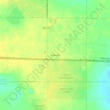
Naam: Topografische kaart Bushland, hoogte, reliëf.
Locatie: Bushland, Potter County, Texas, 79012, United States (35.17289 -102.08038 35.21289 -102.04038)
Gemiddelde hoogte: 1.166 m
Minimale hoogte: 1.152 m
Maximale hoogte: 1.175 m
Bushland is located at 35°11′31″N 102°03′53″W / 35.19194°N 102.06472°W / 35.19194; -102.06472 (35.1919978, -102.0646392), at an elevation of 3,825 feet. The community is situated along Interstate 40, approximately 14 miles west of Amarillo in southwestern Potter County.
Andere topografische kaarten
Klik op een kaart om zijn topografie, zijn hoogte en zijn reliëf te bekijken.
Amarillo
United States > Texas > Potter County
Amarillo, Potter County, Texas, United States
Gemiddelde hoogte: 1.097 m
Amarillo
United States > Texas > Potter County
Amarillo, Potter County, Texas, United States
Gemiddelde hoogte: 1.097 m
Alibates Flint Quarries National Monument
United States > Texas > Potter County
Alibates Flint Quarries National Monument, Potter County, Texas, 79036, United States
Gemiddelde hoogte: 947 m
Amarillo
United States > Texas > Potter County > Amarillo
Amarillo, Potter County, Texas, 79105, United States
Gemiddelde hoogte: 1.090 m