
Topografische kaart Iztapalapa
Interactieve kaart
Klik op de kaart om de hoogte weer te geven.
Over deze kaart
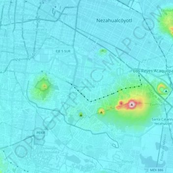
Naam: Topografische kaart Iztapalapa, hoogte, reliëf.
Locatie: Iztapalapa, Mexico City, 09000, Mexico (19.28496 -99.14002 19.40074 -98.96045)
Gemiddelde hoogte: 2.248 m
Minimale hoogte: 2.221 m
Maximale hoogte: 2.632 m
The borough has an average elevation of 2,240 m (7,350 ft) asl and extends over firm land and what was former lake bed of Lake Texcoco. Some of the firm land is alluvial plain but most of it are elevations such as the Cerro de la Estrella (2,460 m or 8,070 ft asl), Peñón Viejo or Peñon del Marqués (2,400 m or 7,900 ft asl), and the Sierra de Santa Catalina, which contains the Cerro Tecuatzi (2,640 m or 8,660 ft asl), Cerro Tetecón (2,480 m or 8,140 ft asl), and the Guadalupe Borrego (2,820 m or 9,250 ft asl), Xaltepec (2,500 m or 8,200 ft asl); and Yuhualixqui (2,420 m or 7,940 ft asl) volcanoes. These are recent geological formations, with evidence of lava flow still existent and none extend over 1,000 meters (3,300 ft) above the valley floor. Culturally, the most important of these elevations is the Cerro de la Estrella, which was the site of the New Fire ceremony. Since the pre-Hispanic period, Lake Texcoco has been drained, leaving behind only two natural river called the Churubusco and La Piedad, which unite to form the Unido River, and a few canals. However, the rivers are confined to large pipes as is one of the canals, and most of the Canal Nacional which forms part of the border of the borough has been filled in to create Calzada La Viga road. For this reason, there are no longer any naturally occurring surface water.
Andere topografische kaarten
Klik op een kaart om zijn topografie, zijn hoogte en zijn reliëf te bekijken.
San Miguel Topilejo
San Miguel Topilejo, Mexico City, 14500, Mexico
Gemiddelde hoogte: 2.740 m
Alameda Central
Alameda Central, Cuauhtémoc, Mexico City, Mexico
Gemiddelde hoogte: 2.235 m
San Miguel Ajusco
San Miguel Ajusco, Mexico City, 14700, Mexico
Gemiddelde hoogte: 2.939 m