
Topografische kaart Álvaro Obregón
Interactieve kaart
Klik op de kaart om de hoogte weer te geven.
Over deze kaart
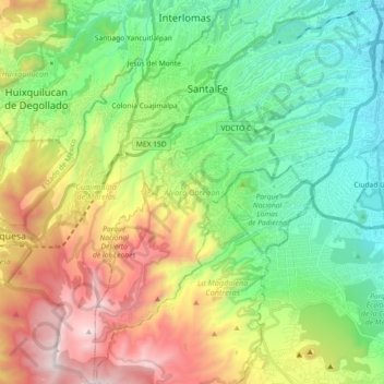
Naam: Topografische kaart Álvaro Obregón, hoogte, reliëf.
Locatie: Álvaro Obregón, Mexico City, Mexico (19.23260 -99.32435 19.40374 -99.17171)
Gemiddelde hoogte: 2.459 m
Minimale hoogte: 2.231 m
Maximale hoogte: 3.535 m
Álvaro Obregón (Spanish pronunciation: [ˈalvaɾo oβɾeˈɣon]) is a borough (demarcación territorial) in the Mexico City.[3] It contains a large portion of the south-west part of Mexico City. It had a 2010 census population of 727,034 inhabitants and lies at an elevation of 2,319 m. above sea level.
Andere topografische kaarten
Klik op een kaart om zijn topografie, zijn hoogte en zijn reliëf te bekijken.
San Miguel Topilejo
San Miguel Topilejo, Mexico City, 14500, Mexico
Gemiddelde hoogte: 2.740 m
Alameda Central
Alameda Central, Cuauhtémoc, Mexico City, Mexico
Gemiddelde hoogte: 2.235 m
San Miguel Ajusco
San Miguel Ajusco, Mexico City, 14700, Mexico
Gemiddelde hoogte: 2.939 m