
Topografische kaart Eagle Rock
Interactieve kaart
Klik op de kaart om de hoogte weer te geven.
Over deze kaart
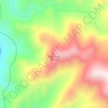
Naam: Topografische kaart Eagle Rock, hoogte, reliëf.
Locatie: Eagle Rock, Idaho County, Idaho, United States of America (45.99542 -114.81654 45.99552 -114.81644)
Gemiddelde hoogte: 1.164 m
Minimale hoogte: 783 m
Maximale hoogte: 1.565 m
Andere topografische kaarten
Klik op een kaart om zijn topografie, zijn hoogte en zijn reliëf te bekijken.
Snake River
United States of America > Idaho
Snake River, Washington County, Idaho, 83672, United States of America
Gemiddelde hoogte: 644 m
Sawtooth National Forest
United States of America > Idaho > Rupert
Sawtooth National Forest, Sharon Court, Rupert, Minidoka County, Idaho, 83350, United States of America
Gemiddelde hoogte: 1.608 m
Genesee
United States of America > Idaho > Genesee
Genesee, Latah County, Idaho, 83832, United States of America
Gemiddelde hoogte: 824 m
Butte County
United States of America > Idaho
Butte County, Idaho, United States of America
Gemiddelde hoogte: 1.914 m
Chinese Peak
United States of America > Idaho
Chinese Peak, Bannock County, Idaho, United States of America
Gemiddelde hoogte: 1.830 m
Camas County
United States of America > Idaho
Camas County, Idaho, United States of America
Gemiddelde hoogte: 2.002 m
Teton
United States of America > Idaho > Teton
Teton, Fremont County, Idaho, 83451, United States of America
Gemiddelde hoogte: 1.509 m
Springston
United States of America > Idaho
Springston, Kootenai County, Idaho, 83833, United States of America
Gemiddelde hoogte: 721 m