
Topografische kaart Camas County
Interactieve kaart
Klik op de kaart om de hoogte weer te geven.
Over deze kaart
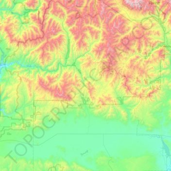
Naam: Topografische kaart Camas County, hoogte, reliëf.
Locatie: Camas County, Idaho, United States of America (43.19842 -115.08668 43.85861 -114.37772)
Gemiddelde hoogte: 2.002 m
Minimale hoogte: 1.375 m
Maximale hoogte: 3.406 m
U.S. Highway 20 runs east–west through the county's center, at elevations just over 5,000 feet (1,520 m) above sea level, connecting west to Mountain Home in Elmore County; to the east it intersects State Highway 75 in Blaine County. The northern terminus of State Highway 46 is at US-20, four miles (6.4 km) east of Fairfield; it runs south over the Mount Bennett Hills into Gooding County and on to Gooding.
Andere topografische kaarten
Klik op een kaart om zijn topografie, zijn hoogte en zijn reliëf te bekijken.
Snake River
United States of America > Idaho
Snake River, Washington County, Idaho, 83672, United States of America
Gemiddelde hoogte: 644 m
Sawtooth National Forest
United States of America > Idaho > Rupert
Sawtooth National Forest, Sharon Court, Rupert, Minidoka County, Idaho, 83350, United States of America
Gemiddelde hoogte: 1.608 m
Genesee
United States of America > Idaho > Genesee
Genesee, Latah County, Idaho, 83832, United States of America
Gemiddelde hoogte: 824 m
Butte County
United States of America > Idaho
Butte County, Idaho, United States of America
Gemiddelde hoogte: 1.914 m
Chinese Peak
United States of America > Idaho
Chinese Peak, Bannock County, Idaho, United States of America
Gemiddelde hoogte: 1.830 m
Eagle Rock
United States of America > Idaho
Eagle Rock, Idaho County, Idaho, United States of America
Gemiddelde hoogte: 1.164 m
Teton
United States of America > Idaho > Teton
Teton, Fremont County, Idaho, 83451, United States of America
Gemiddelde hoogte: 1.509 m
Springston
United States of America > Idaho
Springston, Kootenai County, Idaho, 83833, United States of America
Gemiddelde hoogte: 721 m