
Topografische kaart Snake River
Interactieve kaart
Klik op de kaart om de hoogte weer te geven.
Over deze kaart
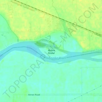
Naam: Topografische kaart Snake River, hoogte, reliëf.
Gemiddelde hoogte: 644 m
Minimale hoogte: 635 m
Maximale hoogte: 653 m
Mountain ranges in the Snake watershed include the Teton Range, Bitterroot Range, Clearwater Mountains, Seven Devils Mountains, and the extreme northwestern end of the Wind River Range. Grand Teton is the highest point in the Snake River watershed, reaching 13,775 feet (4,199 m) in elevation. The elevation of the Snake River is 358 feet (109 m) when it joins the Columbia River.
Andere topografische kaarten
Klik op een kaart om zijn topografie, zijn hoogte en zijn reliëf te bekijken.
Sawtooth National Forest
United States of America > Idaho > Rupert
Sawtooth National Forest, Sharon Court, Rupert, Minidoka County, Idaho, 83350, United States of America
Gemiddelde hoogte: 1.608 m
Genesee
United States of America > Idaho > Genesee
Genesee, Latah County, Idaho, 83832, United States of America
Gemiddelde hoogte: 824 m
Butte County
United States of America > Idaho
Butte County, Idaho, United States of America
Gemiddelde hoogte: 1.914 m
Chinese Peak
United States of America > Idaho
Chinese Peak, Bannock County, Idaho, United States of America
Gemiddelde hoogte: 1.830 m
Camas County
United States of America > Idaho
Camas County, Idaho, United States of America
Gemiddelde hoogte: 2.002 m
Eagle Rock
United States of America > Idaho
Eagle Rock, Idaho County, Idaho, United States of America
Gemiddelde hoogte: 1.164 m
Teton
United States of America > Idaho > Teton
Teton, Fremont County, Idaho, 83451, United States of America
Gemiddelde hoogte: 1.509 m
Springston
United States of America > Idaho
Springston, Kootenai County, Idaho, 83833, United States of America
Gemiddelde hoogte: 721 m