
Topografische kaart Napier
Interactieve kaart
Klik op de kaart om de hoogte weer te geven.
Over deze kaart
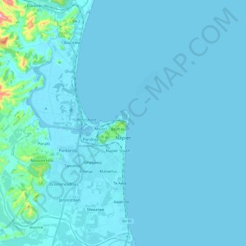
Naam: Topografische kaart Napier, hoogte, reliëf.
Locatie: Napier, Hawke's Bay, New Zealand (-39.57047 176.81127 -39.38819 176.92593)
Gemiddelde hoogte: 12 m
Minimale hoogte: -3 m
Maximale hoogte: 276 m
The city is on Napier Hill and the surrounding Heretaunga Plains at the southeastern edge of Hawke Bay, a large semi-circular bay that dominates the east coast of New Zealand's North Island. The coastline of the city was substantially altered by a large earthquake in 1931. The topography puts Napier in danger from a tsunami, as the centre of the commercial city is near sea level – should the sea ever crest Marine Parade, the sea would run through to Ahuriri. Furthermore, by virtue of its pre-1931 existence, the bulk of Napier is susceptible to soil liquefaction, the risk classed as Very High for the main urban area excluding the hill.
Andere topografische kaarten
Klik op een kaart om zijn topografie, zijn hoogte en zijn reliëf te bekijken.
Hastings
New Zealand > Hawke's Bay > Hastings District
Hastings, Hastings District, Hawke's Bay, 4122, New Zealand
Gemiddelde hoogte: 68 m
Te Haroto
New Zealand > Hawke's Bay > Hastings District
Te Haroto, Hastings District, Hawke's Bay, New Zealand
Gemiddelde hoogte: 647 m
Waipawa Hill
New Zealand > Hawke's Bay > Central Hawke's Bay District
Waipawa Hill, Central Hawke's Bay District, Hawke's Bay, 4210, New Zealand
Gemiddelde hoogte: 253 m
Kereru
New Zealand > Hawke's Bay > Hastings District
Kereru, Hastings District, Hawke's Bay, New Zealand
Gemiddelde hoogte: 305 m
Havelock North
New Zealand > Hawke's Bay > Hastings District
Havelock North, Hastings District, Hawke's Bay, 4130, New Zealand
Gemiddelde hoogte: 45 m
Poukawa
New Zealand > Hawke's Bay > Hastings District
Poukawa, Hastings District, Hawke's Bay, New Zealand
Gemiddelde hoogte: 49 m
Waipukurau
New Zealand > Hawke's Bay > Central Hawke's Bay District
Waipukurau, Central Hawke's Bay District, Hawke's Bay, 4200, New Zealand
Gemiddelde hoogte: 153 m
Wairoa
New Zealand > Hawke's Bay > Wairoa District
Wairoa, Wairoa District, Hawke's Bay, 4108, New Zealand
Gemiddelde hoogte: 23 m
Twyford
New Zealand > Hawke's Bay > Hastings District > Hastings
Twyford, Hastings, Hastings District, Hawke's Bay, 4154, New Zealand
Gemiddelde hoogte: 19 m
Central Hawke's Bay District
Central Hawke's Bay District, Hawke's Bay, New Zealand
Gemiddelde hoogte: 236 m
Nūhaka
New Zealand > Hawke's Bay > Wairoa District
Nūhaka, Wairoa District, Hawke's Bay, 4165, New Zealand
Gemiddelde hoogte: 31 m
Tahaenui River
New Zealand > Hawke's Bay > Wairoa District
Tahaenui River, Wairoa District, Hawke's Bay, 4165, New Zealand
Gemiddelde hoogte: 75 m
Waikoau
New Zealand > Hawke's Bay > Hastings District
Waikoau, Hastings District, Hawke's Bay, New Zealand
Gemiddelde hoogte: 290 m
Tutira
New Zealand > Hawke's Bay > Hastings District
Tutira, Hastings District, Hawke's Bay, New Zealand
Gemiddelde hoogte: 191 m
Mangateretere
New Zealand > Hawke's Bay > Hastings District > Hastings
Mangateretere, Hastings, Hastings District, Hawke's Bay, 4172, New Zealand
Gemiddelde hoogte: 9 m
Kairakau Beach
New Zealand > Hawke's Bay > Central Hawke's Bay District
Kairakau Beach, Central Hawke's Bay District, Hawke's Bay, New Zealand
Gemiddelde hoogte: 46 m
Otane
New Zealand > Hawke's Bay > Central Hawke's Bay District
Otane, Central Hawke's Bay District, Hawke's Bay, 4202, New Zealand
Gemiddelde hoogte: 120 m
Ohuka
New Zealand > Hawke's Bay > Wairoa District
Ohuka, Wairoa District, Hawke's Bay, 4195, New Zealand
Gemiddelde hoogte: 238 m
Pirimai
New Zealand > Hawke's Bay > Napier
Pirimai, Napier, Hawke's Bay, New Zealand
Gemiddelde hoogte: 4 m
Karamea (Red Island)
Karamea (Red Island), Hawke's Bay, New Zealand
Gemiddelde hoogte: 41 m
Ongaonga
New Zealand > Hawke's Bay > Central Hawke's Bay District
Ongaonga, Central Hawke's Bay District, Hawke's Bay, New Zealand
Gemiddelde hoogte: 206 m
Bluff Hill
New Zealand > Hawke's Bay > Napier
Bluff Hill, Napier, Hawke's Bay, 4001, New Zealand
Gemiddelde hoogte: 14 m
Mahia Beach
New Zealand > Hawke's Bay > Wairoa District > Mahia Beach
Mahia Beach, Wairoa District, Hawke's Bay, 4198, New Zealand
Gemiddelde hoogte: 37 m
Maraekakaho
New Zealand > Hawke's Bay > Hastings District > Maraekakaho
Maraekakaho, Hastings District, Hawke's Bay, New Zealand
Gemiddelde hoogte: 118 m
Matangi
New Zealand > Hawke's Bay > Hastings District > Hastings
Matangi, Hastings, Hastings District, Hawke's Bay, 4295, New Zealand
Gemiddelde hoogte: 187 m
Otatara Pā
New Zealand > Hawke's Bay > Hastings District > Napier > Waiohiki
Otatara Pā, Springfield Road, Waiohiki, Napier, Hastings District, Hawke's Bay, 4142, New Zealand
Gemiddelde hoogte: 31 m
Sherenden
New Zealand > Hawke's Bay > Hastings District > Sherenden
Sherenden, Hastings District, Hawke's Bay, New Zealand
Gemiddelde hoogte: 258 m
Lake Tutira
New Zealand > Hawke's Bay > Hastings District
Lake Tutira, Hastings District, Hawke's Bay, New Zealand
Gemiddelde hoogte: 197 m
Crownthorpe
New Zealand > Hawke's Bay > Hastings District
Crownthorpe, Hastings District, Hawke's Bay, New Zealand
Gemiddelde hoogte: 168 m
Lake Waikaremoana
New Zealand > Hawke's Bay > Wairoa District
Lake Waikaremoana, Wairoa District, Hawke's Bay, New Zealand
Gemiddelde hoogte: 706 m
Maraetotara River
New Zealand > Hawke's Bay > Hastings District
Maraetotara River, Hastings District, Hawke's Bay, 4180, New Zealand
Gemiddelde hoogte: 105 m
Wairoa District
Wairoa District, Hawke's Bay, New Zealand
Gemiddelde hoogte: 327 m
Hastings District
Hastings District, Hawke's Bay, New Zealand
Gemiddelde hoogte: 466 m