
Topografische kaart Sandwich
Interactieve kaart
Klik op de kaart om de hoogte weer te geven.
Over deze kaart
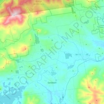
Naam: Topografische kaart Sandwich, hoogte, reliëf.
Gemiddelde hoogte: 373 m
Minimale hoogte: 155 m
Maximale hoogte: 1.200 m
According to the United States Census Bureau, the town has a total area of 94.1 square miles (243.8 km2), of which 90.9 square miles (235.4 km2) are land and 3.3 square miles (8.5 km2) are water, comprising 3.47% of the town. Sandwich is drained to the east by the Bearcamp and Cold rivers, to the northwest by the Beebe River, to the southwest by Squam Lake, and to the south by the Red Hill River. The Bearcamp and Cold rivers are part of the Saco River watershed, draining east into Maine, while the remainder of the town is part of the Merrimack River watershed, draining south to Massachusetts. Mount Israel, elevation 2,630 feet (802 m) above sea level, is at the center. Part of the Squam Mountains is in the west. Part of the Sandwich Range is in the north, including the 3,993-foot (1,217 m) Sandwich Mountain (also known as Sandwich Dome), the highest point in town as well as in Carroll County.
Andere topografische kaarten
Klik op een kaart om zijn topografie, zijn hoogte en zijn reliëf te bekijken.
Eaton
United States > New Hampshire > Carroll County
Eaton, Carroll County, New Hampshire, 03832, United States
Gemiddelde hoogte: 262 m
Ossipee
United States > New Hampshire > Carroll County
Ossipee, Carroll County, New Hampshire, United States
Gemiddelde hoogte: 217 m
Flat Mountain
United States > New Hampshire > Carroll County > Sandwich
Flat Mountain, Sandwich, Carroll County, New Hampshire, United States
Gemiddelde hoogte: 629 m
Moultonborough
United States > New Hampshire > Carroll County
Moultonborough, Carroll County, New Hampshire, United States
Gemiddelde hoogte: 243 m
Albany
United States > New Hampshire > Carroll County > Albany
Albany, Carroll County, New Hampshire, United States
Gemiddelde hoogte: 276 m
Bayle Mountain
United States > New Hampshire > Carroll County > Ossipee
Bayle Mountain, Ossipee, Carroll County, New Hampshire, United States
Gemiddelde hoogte: 405 m
Bartlett
United States > New Hampshire > Carroll County
Bartlett, Carroll County, New Hampshire, United States
Gemiddelde hoogte: 493 m
Whitton Pond
United States > New Hampshire > Carroll County > Albany
Whitton Pond, Albany, Carroll County, New Hampshire, United States
Gemiddelde hoogte: 273 m
Wolfeboro
United States > New Hampshire > Carroll County
Wolfeboro, Carroll County, New Hampshire, United States
Gemiddelde hoogte: 213 m
Albany
United States > New Hampshire > Carroll County > Albany
Albany, Carroll County, New Hampshire, 03818, United States
Gemiddelde hoogte: 409 m
Tamworth
United States > New Hampshire > Carroll County > Tamworth
Tamworth, Carroll County, New Hampshire, United States
Gemiddelde hoogte: 263 m
Conway
United States > New Hampshire > Carroll County
Conway, Carroll County, New Hampshire, United States
Gemiddelde hoogte: 256 m
Freedom
United States > New Hampshire > Carroll County
Freedom, Carroll County, New Hampshire, 03836, United States
Gemiddelde hoogte: 224 m