
Topografische kaart Wolfeboro
Interactieve kaart
Klik op de kaart om de hoogte weer te geven.
Over deze kaart
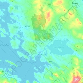
Naam: Topografische kaart Wolfeboro, hoogte, reliëf.
Locatie: Wolfeboro, Carroll County, New Hampshire, United States (43.53895 -71.28488 43.68028 -71.05920)
Gemiddelde hoogte: 213 m
Minimale hoogte: 149 m
Maximale hoogte: 555 m
According to the United States Census Bureau, the town has a total area of 58.5 square miles (151.4 km2), of which 48.0 square miles (124.2 km2) are land and 10.5 square miles (27.2 km2) are water, comprising 17.95% of the town.[1] Wolfeboro is drained by the Smith River, which is the outlet of Lake Wentworth and an inlet of Lake Winnipesaukee. Via Winnipesaukee, the town is part of the Merrimack River watershed. The highest point in town is Moody Mountain, elevation 1,420 feet (430 m) above sea level, located near the northern boundary.
Andere topografische kaarten
Klik op een kaart om zijn topografie, zijn hoogte en zijn reliëf te bekijken.
Eaton
United States > New Hampshire > Carroll County
Eaton, Carroll County, New Hampshire, 03832, United States
Gemiddelde hoogte: 262 m
Ossipee
United States > New Hampshire > Carroll County
Ossipee, Carroll County, New Hampshire, United States
Gemiddelde hoogte: 217 m
Sandwich
United States > New Hampshire > Carroll County
Sandwich, Carroll County, New Hampshire, 03259, United States
Gemiddelde hoogte: 373 m
Flat Mountain
United States > New Hampshire > Carroll County > Sandwich
Flat Mountain, Sandwich, Carroll County, New Hampshire, United States
Gemiddelde hoogte: 629 m
Moultonborough
United States > New Hampshire > Carroll County
Moultonborough, Carroll County, New Hampshire, United States
Gemiddelde hoogte: 243 m
Albany
United States > New Hampshire > Carroll County > Albany
Albany, Carroll County, New Hampshire, United States
Gemiddelde hoogte: 276 m
Bayle Mountain
United States > New Hampshire > Carroll County > Ossipee
Bayle Mountain, Ossipee, Carroll County, New Hampshire, United States
Gemiddelde hoogte: 405 m
Bartlett
United States > New Hampshire > Carroll County
Bartlett, Carroll County, New Hampshire, United States
Gemiddelde hoogte: 493 m
Whitton Pond
United States > New Hampshire > Carroll County > Albany
Whitton Pond, Albany, Carroll County, New Hampshire, United States
Gemiddelde hoogte: 273 m
Albany
United States > New Hampshire > Carroll County > Albany
Albany, Carroll County, New Hampshire, 03818, United States
Gemiddelde hoogte: 409 m
Tamworth
United States > New Hampshire > Carroll County > Tamworth
Tamworth, Carroll County, New Hampshire, United States
Gemiddelde hoogte: 263 m
Conway
United States > New Hampshire > Carroll County
Conway, Carroll County, New Hampshire, United States
Gemiddelde hoogte: 256 m
Freedom
United States > New Hampshire > Carroll County
Freedom, Carroll County, New Hampshire, 03836, United States
Gemiddelde hoogte: 224 m