
Topografische kaart Bartlett
Interactieve kaart
Klik op de kaart om de hoogte weer te geven.
Over deze kaart
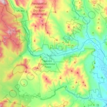
Naam: Topografische kaart Bartlett, hoogte, reliëf.
Locatie: Bartlett, Carroll County, New Hampshire, United States (44.02223 -71.38260 44.13978 -71.08385)
Gemiddelde hoogte: 493 m
Minimale hoogte: 137 m
Maximale hoogte: 1.285 m
According to the United States Census Bureau, the town has a total area of 75.3 square miles (195 km2), of which 74.9 square miles (194 km2) is land and 0.4 square miles (1.0 km2), or 0.57%, is water. Bartlett is drained by the Saco and Ellis rivers. The highest point in Bartlett is Mount Tremont, elevation 3,371 feet (1,027 m) above sea level. Mount Parker, elevation 3,004 ft (916 m), is in the north, and Bear Mountain, elevation 3,200 ft (980 m), is on the southern boundary. Bartlett lies fully within the Saco River watershed.
Andere topografische kaarten
Klik op een kaart om zijn topografie, zijn hoogte en zijn reliëf te bekijken.
Eaton
United States > New Hampshire > Carroll County
Eaton, Carroll County, New Hampshire, 03832, United States
Gemiddelde hoogte: 262 m
Ossipee
United States > New Hampshire > Carroll County
Ossipee, Carroll County, New Hampshire, United States
Gemiddelde hoogte: 217 m
Sandwich
United States > New Hampshire > Carroll County
Sandwich, Carroll County, New Hampshire, 03259, United States
Gemiddelde hoogte: 373 m
Flat Mountain
United States > New Hampshire > Carroll County > Sandwich
Flat Mountain, Sandwich, Carroll County, New Hampshire, United States
Gemiddelde hoogte: 629 m
Moultonborough
United States > New Hampshire > Carroll County
Moultonborough, Carroll County, New Hampshire, United States
Gemiddelde hoogte: 243 m
Albany
United States > New Hampshire > Carroll County > Albany
Albany, Carroll County, New Hampshire, United States
Gemiddelde hoogte: 276 m
Bayle Mountain
United States > New Hampshire > Carroll County > Ossipee
Bayle Mountain, Ossipee, Carroll County, New Hampshire, United States
Gemiddelde hoogte: 405 m
Whitton Pond
United States > New Hampshire > Carroll County > Albany
Whitton Pond, Albany, Carroll County, New Hampshire, United States
Gemiddelde hoogte: 273 m
Wolfeboro
United States > New Hampshire > Carroll County
Wolfeboro, Carroll County, New Hampshire, United States
Gemiddelde hoogte: 213 m
Albany
United States > New Hampshire > Carroll County > Albany
Albany, Carroll County, New Hampshire, 03818, United States
Gemiddelde hoogte: 409 m
Tamworth
United States > New Hampshire > Carroll County > Tamworth
Tamworth, Carroll County, New Hampshire, United States
Gemiddelde hoogte: 263 m
Conway
United States > New Hampshire > Carroll County
Conway, Carroll County, New Hampshire, United States
Gemiddelde hoogte: 256 m
Freedom
United States > New Hampshire > Carroll County
Freedom, Carroll County, New Hampshire, 03836, United States
Gemiddelde hoogte: 224 m