
Topografische kaart Nowy Sącz
Interactieve kaart
Klik op de kaart om de hoogte weer te geven.
Over deze kaart
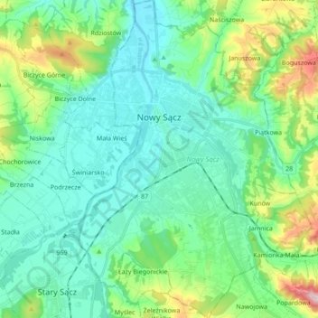
Naam: Topografische kaart Nowy Sącz, hoogte, reliëf.
Locatie: Nowy Sącz, Lesser Poland Voivodeship, Poland (49.55494 20.64841 49.66556 20.76487)
Gemiddelde hoogte: 350 m
Minimale hoogte: 268 m
Maximale hoogte: 635 m
Nowy Sącz is located at the confluence of the Kamienica River and Dunajec, about 20 kilometres (12 miles) north of the Slovak border, in the Sądecka Valley (Kotlina Sądecka) at an altitude of 381 metres (1,250 feet). It is surrounded by ranges of the eastern Outer Western Carpathian Mountains: Beskid Sądecki to the south, Beskid Wyspowy to the west, Beskid Niski to the southeast, and the foothills of Pogórze Rożnowskie to the north. The geological basis is Carpathian flysch – an undifferentiated grey-banded sandstone – with alluvial sediment from the Dunajec, Poprad, and Kamienica rivers in the valley basin.
Andere topografische kaarten
Klik op een kaart om zijn topografie, zijn hoogte en zijn reliëf te bekijken.
Krakow
Poland > Lesser Poland Voivodeship
Krakow, Lesser Poland Voivodeship, Poland
Gemiddelde hoogte: 258 m
Tarnów
Poland > Lesser Poland Voivodeship > Tarnów
Tarnów, Lesser Poland Voivodeship, Poland
Gemiddelde hoogte: 215 m
Kościuszko Mound
Poland > Lesser Poland Voivodeship > Krakow
Kościuszko Mound, Plac Paula McCartney'a, Zwierzyniec, Krakow, Lesser Poland Voivodeship, 30-210, Poland
Gemiddelde hoogte: 220 m
Spytkowice
Poland > Lesser Poland Voivodeship > Wadowice County
Spytkowice, gmina Spytkowice, Wadowice County, Lesser Poland Voivodeship, 34-116, Poland
Gemiddelde hoogte: 241 m
Andrychów
Poland > Lesser Poland Voivodeship > Wadowice County
Andrychów, gmina Andrychów, Wadowice County, Lesser Poland Voivodeship, 34-120, Poland
Gemiddelde hoogte: 347 m
Małe Ciche
Poland > Lesser Poland Voivodeship > Tatra County
Małe Ciche, gmina Poronin, Tatra County, Lesser Poland Voivodeship, Poland
Gemiddelde hoogte: 1.012 m
Pcim
Poland > Lesser Poland Voivodeship > Myślenice County
Pcim, gmina Pcim, Myślenice County, Lesser Poland Voivodeship, 32-432, Poland
Gemiddelde hoogte: 483 m
Szczawa
Poland > Lesser Poland Voivodeship > Limanowa County
Szczawa, gmina Kamienica, Limanowa County, Lesser Poland Voivodeship, 34-607, Poland
Gemiddelde hoogte: 706 m
Park Krajobrazowy Dolinki Krakowskie
Poland > Lesser Poland Voivodeship > Kraków County > Szklary
Park Krajobrazowy Dolinki Krakowskie, Szklary, gmina Jerzmanowice-Przeginia, Kraków County, Lesser Poland Voivodeship, 32-063, Poland
Gemiddelde hoogte: 341 m
Podzamcze
Poland > Lesser Poland Voivodeship > Kraków County > Korzkiew > Podzamcze
Podzamcze, Korzkiew, gmina Zielonki, Kraków County, Lesser Poland Voivodeship, Poland
Gemiddelde hoogte: 321 m
Bielańsko-Tyniecki Park Krajobrazowy
Poland > Lesser Poland Voivodeship > Kraków County > Krakow
Bielańsko-Tyniecki Park Krajobrazowy, Krakow, gmina Liszki, Kraków County, Lesser Poland Voivodeship, Poland
Gemiddelde hoogte: 239 m
Żbik
Poland > Lesser Poland Voivodeship > Kraków County > Krzeszowice
Żbik, Krzeszowice, gmina Krzeszowice, Kraków County, Lesser Poland Voivodeship, 32-065, Poland
Gemiddelde hoogte: 317 m
Tenczyński Park Krajobrazowy
Poland > Lesser Poland Voivodeship > Kraków County
Tenczyński Park Krajobrazowy, Kraków County, Lesser Poland Voivodeship, Poland
Gemiddelde hoogte: 308 m
Rudniański Park Krajobrazowy
Poland > Lesser Poland Voivodeship > Chrzanów County > Mirów
Rudniański Park Krajobrazowy, Mirów, gmina Alwernia, Chrzanów County, Lesser Poland Voivodeship, Poland
Gemiddelde hoogte: 265 m
Granice
Poland > Lesser Poland Voivodeship > Limanowa County > Sadek
Granice, Sadek, gmina Jodłownik, Limanowa County, Lesser Poland Voivodeship, 34-620, Poland
Gemiddelde hoogte: 405 m
Stasindowie
Poland > Lesser Poland Voivodeship > Tatra County > Gliczarów Górny
Stasindowie, Gliczarów Górny, gmina Biały Dunajec, Tatra County, Lesser Poland Voivodeship, 34-531, Poland
Gemiddelde hoogte: 894 m
Balin
Poland > Lesser Poland Voivodeship > Chrzanów County
Balin, gmina Chrzanów, Chrzanów County, Lesser Poland Voivodeship, Poland
Gemiddelde hoogte: 314 m
Zakopane
Poland > Lesser Poland Voivodeship > Tatra County
Zakopane, Tatra County, Lesser Poland Voivodeship, Poland
Gemiddelde hoogte: 1.199 m
Ciptowski
Poland > Lesser Poland Voivodeship > Nowy Targ County > Łapszanka
Ciptowski, Łapszanka, gmina Łapsze Niżne, Nowy Targ County, Lesser Poland Voivodeship, 34-442, Poland
Gemiddelde hoogte: 898 m
Łapanów
Poland > Lesser Poland Voivodeship > Bochnia County
Łapanów, gmina Łapanów, Bochnia County, Lesser Poland Voivodeship, 32-740, Poland
Gemiddelde hoogte: 266 m
Gorlice
Poland > Lesser Poland Voivodeship > Gorlice County
Gorlice, Gorlice County, Lesser Poland Voivodeship, Poland
Gemiddelde hoogte: 315 m
Obidowa
Poland > Lesser Poland Voivodeship > Nowy Targ County
Obidowa, gmina Nowy Targ, Nowy Targ County, Lesser Poland Voivodeship, Poland, Turbacz
Gemiddelde hoogte: 1.117 m
Korab
Poland > Lesser Poland Voivodeship > Limanowa County > Jaworzna
Korab, Jaworzna, gmina Laskowa, Limanowa County, Lesser Poland Voivodeship, 34-602, Poland
Gemiddelde hoogte: 593 m
Miechów
Poland > Lesser Poland Voivodeship > powiat miechowski
Miechów, gmina Miechów, powiat miechowski, Lesser Poland Voivodeship, Poland
Gemiddelde hoogte: 311 m
Bystra
Poland > Lesser Poland Voivodeship > Gorlice County
Bystra, gmina Gorlice, Gorlice County, Lesser Poland Voivodeship, 38-317, Poland
Gemiddelde hoogte: 432 m
Piotrkowice
Poland > Lesser Poland Voivodeship > Tarnów County
Piotrkowice, gmina Tuchów, Tarnów County, Lesser Poland Voivodeship, Poland
Gemiddelde hoogte: 286 m
Siedlec
Poland > Lesser Poland Voivodeship > Tarnów County
Siedlec, gmina Radłów, Tarnów County, Lesser Poland Voivodeship, Poland
Gemiddelde hoogte: 184 m
Dąbrowa Tarnowska
Poland > Lesser Poland Voivodeship > Dąbrowa County
Dąbrowa Tarnowska, gmina Dąbrowa Tarnowska, Dąbrowa County, Lesser Poland Voivodeship, 33-200, Poland
Gemiddelde hoogte: 202 m
Grzechynia Dolna
Poland > Lesser Poland Voivodeship > Sucha County > Grzechynia
Grzechynia Dolna, Grzechynia, gmina Maków Podhalański, Sucha County, Lesser Poland Voivodeship, 34-220, Poland
Gemiddelde hoogte: 452 m
Dwudniaki
Poland > Lesser Poland Voivodeship > Tarnów County > Wierzchosławice
Dwudniaki, Wierzchosławice, gmina Wierzchosławice, Tarnów County, Lesser Poland Voivodeship, 33-122, Poland
Gemiddelde hoogte: 192 m
Olszyny
Poland > Lesser Poland Voivodeship > Chrzanów County
Olszyny, gmina Babice, Chrzanów County, Lesser Poland Voivodeship, Poland
Gemiddelde hoogte: 233 m
Leszczynowa
Poland > Lesser Poland Voivodeship > Kraków County > Chrosna
Leszczynowa, Chrosna, gmina Liszki, Kraków County, Lesser Poland Voivodeship, Poland
Gemiddelde hoogte: 307 m
Kleszczów
Poland > Lesser Poland Voivodeship > Kraków County
Kleszczów, gmina Zabierzów, Kraków County, Lesser Poland Voivodeship, Poland
Gemiddelde hoogte: 309 m
Morskie Oko
Poland > Lesser Poland Voivodeship > Tatra County > Brzegi
Morskie Oko, Brzegi, gmina Bukowina Tatrzańska, Tatra County, Lesser Poland Voivodeship, Poland
Gemiddelde hoogte: 1.749 m
Lipnica Wielka
Poland > Lesser Poland Voivodeship > Nowy Targ County
Lipnica Wielka, gmina Lipnica Wielka, Nowy Targ County, Lesser Poland Voivodeship, 34-483, Poland
Gemiddelde hoogte: 753 m
Białka Tatrzańska
Poland > Lesser Poland Voivodeship > Tatra County
Białka Tatrzańska, gmina Bukowina Tatrzańska, Tatra County, Lesser Poland Voivodeship, 34-405, Poland
Gemiddelde hoogte: 766 m
Kaniówka
Poland > Lesser Poland Voivodeship > Tatra County > Białka Tatrzańska
Kaniówka, Białka Tatrzańska, gmina Bukowina Tatrzańska, Tatra County, Lesser Poland Voivodeship, 34-405, Poland
Gemiddelde hoogte: 794 m
Sułoszowa
Poland > Lesser Poland Voivodeship > Kraków County
Sułoszowa, gmina Sułoszowa, Kraków County, Lesser Poland Voivodeship, 32-045, Poland
Gemiddelde hoogte: 442 m
Skała
Poland > Lesser Poland Voivodeship > Tarnów County > Koszyce Małe
Skała, Koszyce Małe, gmina Tarnów, Tarnów County, Lesser Poland Voivodeship, 33-111, Poland
Gemiddelde hoogte: 231 m
Tatry
Poland > Lesser Poland Voivodeship > Tatra County > Zakopane
Tatry, Zakopane, Tatra County, Lesser Poland Voivodeship, Poland
Gemiddelde hoogte: 1.647 m
Rabka-Zdrój
Poland > Lesser Poland Voivodeship > Nowy Targ County
Rabka-Zdrój, gmina Rabka-Zdrój, Nowy Targ County, Lesser Poland Voivodeship, 34-700, Poland
Gemiddelde hoogte: 594 m
Babia Góra / Babia hora
Poland > Lesser Poland Voivodeship > Sucha County > Zawoja
Babia Góra / Babia hora, Zawoja, gmina Zawoja, Sucha County, Lesser Poland Voivodeship, Poland
Gemiddelde hoogte: 1.395 m
Tenczyn
Poland > Lesser Poland Voivodeship > Myślenice County
Tenczyn, gmina Lubień, Myślenice County, Lesser Poland Voivodeship, Poland
Gemiddelde hoogte: 620 m
Szklary
Poland > Lesser Poland Voivodeship > Kraków County
Szklary, gmina Jerzmanowice-Przeginia, Kraków County, Lesser Poland Voivodeship, Poland
Gemiddelde hoogte: 411 m
Charsznica
Poland > Lesser Poland Voivodeship > powiat miechowski
Charsznica, gmina Charsznica, powiat miechowski, Lesser Poland Voivodeship, Poland
Gemiddelde hoogte: 320 m
Czarny Potok
Poland > Lesser Poland Voivodeship > Tatra County > Zakopane
Czarny Potok, Osiedle Kasprusie, Zakopane, Tatra County, Lesser Poland Voivodeship, 34-500, Poland
Gemiddelde hoogte: 869 m
Werychów
Poland > Lesser Poland Voivodeship > Kraków County > Balice
Werychów, Balice, gmina Zabierzów, Kraków County, Lesser Poland Voivodeship, 31-083, Poland
Gemiddelde hoogte: 238 m
Siedlisko
Poland > Lesser Poland Voivodeship > Kraków County > Radziszów
Siedlisko, Radziszów, gmina Skawina, Kraków County, Lesser Poland Voivodeship, 32-052, Poland
Gemiddelde hoogte: 262 m
Wielki Giewont
Poland > Lesser Poland Voivodeship > Tatra County > Zakopane
Wielki Giewont, Zakopane, Tatra County, Lesser Poland Voivodeship, Poland
Gemiddelde hoogte: 1.478 m
Myślenice
Poland > Lesser Poland Voivodeship > Myślenice County
Myślenice, gmina Myślenice, Myślenice County, Lesser Poland Voivodeship, 32-400, Poland
Gemiddelde hoogte: 384 m