
Topografische kaart Petroleum County
Interactieve kaart
Klik op de kaart om de hoogte weer te geven.
Over deze kaart
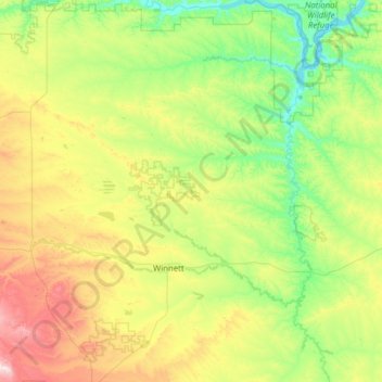
Naam: Topografische kaart Petroleum County, hoogte, reliëf.
Locatie: Petroleum County, Montana, United States (46.74808 -108.73688 47.59845 -107.82551)
Gemiddelde hoogte: 916 m
Minimale hoogte: 675 m
Maximale hoogte: 1.617 m
The county's eastern boundary is formed by the Musselshell River. According to the United States Census Bureau, the county has a total area of 1,674 square miles (4,340 km2), 1,655 square miles (4,290 km2) land and 19 square miles (49 km2) (1.1%) water. Its average elevation is 2,250–4,000 feet (690–1,220 m). The land lies in the Missouri Plateau section of the Great Plains. The uplands are generally of fairly level land and valleys while the general topography is of rolling hills and valleys except for sharp gullies on the side slopes of Missouri and Musselshell Rivers in certain stretches. The southern part of the county consists of moderate hill slopes and gentle valleys, interspersed with steep cliffs.
Andere topografische kaarten
Klik op een kaart om zijn topografie, zijn hoogte en zijn reliëf te bekijken.
Missoula
United States > Montana > Missoula County
Missoula, Missoula County, Montana, United States
Gemiddelde hoogte: 1.173 m
Butte
United States > Montana > Silver Bow County
Butte, Silver Bow County, Montana, United States
Gemiddelde hoogte: 1.909 m
Kalispell
United States > Montana > Flathead County
Kalispell, Flathead County, Montana, United States
Gemiddelde hoogte: 934 m
Logan
United States > Montana > Gallatin County
Logan, Gallatin County, Montana, United States
Gemiddelde hoogte: 1.294 m
Trego
United States > Montana > Lincoln County
Trego, Lincoln County, Montana, 59934, United States
Gemiddelde hoogte: 974 m
Stillwater County
Stillwater County, Montana, United States
Gemiddelde hoogte: 1.474 m
Carr Trailer Court
United States > Montana > Stillwater County > Columbus
Carr Trailer Court, Columbus, Stillwater County, Montana, United States
Gemiddelde hoogte: 1.119 m
Franklin Park
United States > Montana > Missoula County > Missoula
Franklin Park, Franklin to the Fort, Missoula, Missoula County, Montana, United States
Gemiddelde hoogte: 968 m
Red Rock River
United States > Montana > Beaverhead County > Dell
Red Rock River, Dell, Beaverhead County, Montana, United States
Gemiddelde hoogte: 1.834 m
Jackson
United States > Montana > Beaverhead County
Jackson, Beaverhead County, Montana, 59736, United States
Gemiddelde hoogte: 1.995 m
Lois Lake
United States > Montana > Powell County
Lois Lake, Powell County, Montana, United States
Gemiddelde hoogte: 1.671 m
Flathead County
Flathead County, Montana, United States
Gemiddelde hoogte: 1.497 m
Twin Bridges
United States > Montana > Madison County
Twin Bridges, Madison County, Montana, United States
Gemiddelde hoogte: 1.414 m
Lakeside
United States > Montana > Flathead County
Lakeside, Flathead County, Montana, 59922, United States
Gemiddelde hoogte: 1.034 m
Rattlesnake Wilderness
United States > Montana > Missoula County
Rattlesnake Wilderness, Missoula County, Montana, United States
Gemiddelde hoogte: 1.847 m
Roosevelt County
Roosevelt County, Montana, United States
Gemiddelde hoogte: 703 m
Wild Horse Island
United States > Montana > Lake County
Wild Horse Island, Lake County, Montana, United States
Gemiddelde hoogte: 916 m
Red Lodge
United States > Montana > Carbon County
Red Lodge, Carbon County, Montana, 59068, United States
Gemiddelde hoogte: 1.720 m
Victor
United States > Montana > Ravalli County
Victor, Ravalli County, Montana, United States
Gemiddelde hoogte: 1.047 m
Winston
United States > Montana > Broadwater County > Winston
Winston, Broadwater County, Montana, 59647, United States
Gemiddelde hoogte: 1.335 m
Jefferson County
Jefferson County, Montana, United States
Gemiddelde hoogte: 1.750 m
Treasure County
Treasure County, Montana, United States
Gemiddelde hoogte: 927 m
Thompson Park
United States > Montana > Silver Bow County > Butte
Thompson Park, Butte, Silver Bow County, Montana, United States
Gemiddelde hoogte: 1.870 m
Baldy
United States > Montana > Powell County
Baldy, Powell County, Montana, United States
Gemiddelde hoogte: 2.473 m
Riata Park
United States > Montana > Missoula County > Missoula
Riata Park, 44 Ranch, Orchard Homes, Missoula, Missoula County, Montana, United States
Gemiddelde hoogte: 961 m
Wisdom
United States > Montana > Beaverhead County > Wisdom
Wisdom, Beaverhead County, Montana, 59761, United States
Gemiddelde hoogte: 1.848 m
Ashenhurst Number 2 Dam
United States > Montana > Rosebud County
Ashenhurst Number 2 Dam, Rosebud County, Montana, United States
Gemiddelde hoogte: 955 m
Baker
United States > Montana > Fallon County
Baker, Fallon County, Montana, 59313, United States
Gemiddelde hoogte: 901 m
Sugar Loaf Mountain
United States > Montana > Park County
Sugar Loaf Mountain, Park County, Montana, United States
Gemiddelde hoogte: 2.343 m
McLeod
United States > Montana > Sweet Grass County
McLeod, Sweet Grass County, Montana, United States
Gemiddelde hoogte: 1.564 m
Hysham
United States > Montana > Treasure County
Hysham, Treasure County, Montana, United States
Gemiddelde hoogte: 810 m
St. Regis
United States > Montana > Mineral County
St. Regis, Mineral County, Montana, 59866, United States
Gemiddelde hoogte: 838 m
Seeley Lake
United States > Montana > Missoula County
Seeley Lake, Missoula County, Montana, United States
Gemiddelde hoogte: 1.348 m
Pray Lake
United States > Montana > Glacier County
Pray Lake, Glacier County, Montana, United States
Gemiddelde hoogte: 1.717 m
Baseline
United States > Montana > Yellowstone County
Baseline, Yellowstone County, Montana, 59103, United States
Gemiddelde hoogte: 1.043 m
Ski Hill
United States > Montana > Beaverhead County
Ski Hill, Beaverhead County, Montana, United States
Gemiddelde hoogte: 2.215 m
Bowman Lake
United States > Montana > Flathead County
Bowman Lake, Flathead County, Montana, United States
Gemiddelde hoogte: 1.639 m
Livingston
United States > Montana > Park County
Livingston, Park County, Montana, United States
Gemiddelde hoogte: 1.421 m
Poplar
United States > Montana > Roosevelt County
Poplar, Poplar District, Roosevelt County, Montana, United States
Gemiddelde hoogte: 600 m
Choteau
United States > Montana > Teton County
Choteau, Teton County, Montana, United States
Gemiddelde hoogte: 1.173 m
Plains
United States > Montana > Sanders County
Plains, Sanders County, Montana, United States
Gemiddelde hoogte: 775 m
Bozeman
United States > Montana > Gallatin County
Bozeman, Gallatin County, Montana, United States
Gemiddelde hoogte: 1.495 m
Wolf Creek
United States > Montana > Lincoln County
Wolf Creek, Lincoln County, Montana, United States
Gemiddelde hoogte: 1.225 m
Gluten
United States > Montana > Daniels County
Gluten, Daniels County, Montana, United States
Gemiddelde hoogte: 816 m
Ozone Layer Dam
United States > Montana > Wheatland County
Ozone Layer Dam, Wheatland County, Montana, United States
Gemiddelde hoogte: 1.413 m
Emigrant
United States > Montana > Park County
Emigrant, Park County, Montana, 59027, United States
Gemiddelde hoogte: 1.530 m
Martin City
United States > Montana > Flathead County > Martin City
Martin City, Flathead County, Montana, 59926, United States
Gemiddelde hoogte: 989 m
Ear Mountain
United States > Montana > Teton County
Ear Mountain, Teton County, Montana, United States
Gemiddelde hoogte: 2.138 m
Columbia Falls
United States > Montana > Flathead County
Columbia Falls, Flathead County, Montana, 59912, United States
Gemiddelde hoogte: 934 m