
Topografische kaart Ocean Shores
Interactieve kaart
Klik op de kaart om de hoogte weer te geven.
Over deze kaart
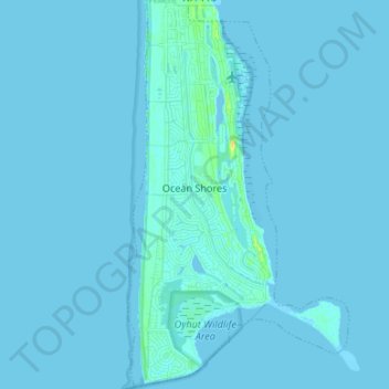
Naam: Topografische kaart Ocean Shores, hoogte, reliëf.
Gemiddelde hoogte: 1 m
Minimale hoogte: -2 m
Maximale hoogte: 20 m
Andere topografische kaarten
Klik op een kaart om zijn topografie, zijn hoogte en zijn reliëf te bekijken.
Vesta
United States > Washington > Grays Harbor County
Vesta, Grays Harbor County, Washington, United States
Gemiddelde hoogte: 86 m
Roosevelt Beach Conservation Area
United States > Washington > Grays Harbor County > Ocean Grove
Roosevelt Beach Conservation Area, Ocean Grove, Grays Harbor County, Washington, United States
Gemiddelde hoogte: 18 m
Humptulips
United States > Washington > Grays Harbor County
Humptulips, Grays Harbor County, Washington, United States
Gemiddelde hoogte: 108 m
Artic
United States > Washington > Grays Harbor County
Artic, Grays Harbor County, Washington, United States
Gemiddelde hoogte: 75 m
Grisdale
United States > Washington > Grays Harbor County
Grisdale, Grays Harbor County, Washington, United States
Gemiddelde hoogte: 354 m
Elma
United States > Washington > Grays Harbor County > Elma
Elma, Grays Harbor County, Washington, United States
Gemiddelde hoogte: 36 m
McCleary
United States > Washington > Grays Harbor County > McCleary > McCleary
McCleary, Grays Harbor County, Washington, 98557, United States
Gemiddelde hoogte: 108 m