
Topografische kaart Columbia River
Interactieve kaart
Klik op de kaart om de hoogte weer te geven.
Over deze kaart
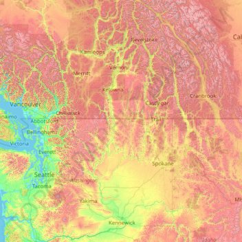
Naam: Topografische kaart Columbia River, hoogte, reliëf.
Locatie: Columbia River, 97014, United States (45.54445 -124.07186 52.12484 -115.84933)
Gemiddelde hoogte: 1.102 m
Minimale hoogte: -2 m
Maximale hoogte: 4.151 m
The Columbia's heavy flow and large elevation drop over a short distance, 2.16 feet per mile (40.9 cm/km), give it tremendous capacity for hydroelectricity generation. In comparison, the Mississippi drops less than 0.65 feet per mile (12.3 cm/km). The Columbia alone possesses one-third of the United States's hydroelectric potential. In 2012, the river and its tributaries accounted for 29 GW of hydroelectric generating capacity, contributing 44 percent of the total hydroelectric generation in the nation.
Andere topografische kaarten
Klik op een kaart om zijn topografie, zijn hoogte en zijn reliëf te bekijken.
Los Angeles
Los Angeles, Los Angeles County, California, United States
Gemiddelde hoogte: 241 m
Indianapolis
United States > Indiana > Indianapolis
Indianapolis, Marion County, Indiana, 46204, United States
Gemiddelde hoogte: 241 m
Appalachian Mountains
United States > North Carolina > Yancey County
Appalachian Mountains, Yancey County, North Carolina, United States
Gemiddelde hoogte: 1.463 m
Cochise County
Cochise County, Arizona, United States
Gemiddelde hoogte: 1.410 m
Clarksville
United States > Tennessee > Montgomery County
Clarksville, Montgomery County, Middle Tennessee, Tennessee, United States
Gemiddelde hoogte: 155 m
Spokane
United States > Washington > Spokane County
Spokane, Spokane County, Washington, United States
Gemiddelde hoogte: 655 m
Des Moines
United States > Iowa > Polk County
Des Moines, Polk County, Iowa, United States
Gemiddelde hoogte: 264 m
Jacksonville
United States > Florida > Duval County
Jacksonville, Duval County, Florida, United States
Gemiddelde hoogte: 10 m
Highlands Ranch
United States > Colorado > Douglas County
Highlands Ranch, Douglas County, Colorado, 80126, United States
Gemiddelde hoogte: 1.758 m
Lancaster County
Lancaster County, Pennsylvania, United States
Gemiddelde hoogte: 158 m
New Orleans
United States > Louisiana > Orleans Parish
New Orleans, Orleans Parish, Louisiana, United States
Gemiddelde hoogte: 1 m
Santa Cruz
United States > California > Santa Cruz County
Santa Cruz, Santa Cruz County, California, United States
Gemiddelde hoogte: 89 m
Steamboat Springs
United States > Colorado > Routt County
Steamboat Springs, Routt County, Colorado, United States
Gemiddelde hoogte: 2.228 m
Barnstable County
Barnstable County, Massachusetts, United States
Gemiddelde hoogte: 7 m
Central Park
United States > New York > New York County > New York
Central Park, New York County, New York, United States
Gemiddelde hoogte: 26 m
Missoula
United States > Montana > Missoula County
Missoula, Missoula County, Montana, United States
Gemiddelde hoogte: 1.173 m