
Topografische kaart Owyhee County
Interactieve kaart
Klik op de kaart om de hoogte weer te geven.
Over deze kaart
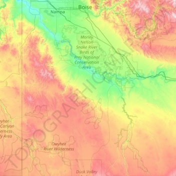
Naam: Topografische kaart Owyhee County, hoogte, reliëf.
Locatie: Owyhee County, Idaho, United States (41.99781 -117.02700 43.68114 -115.03590)
Gemiddelde hoogte: 1.372 m
Minimale hoogte: 670 m
Maximale hoogte: 2.903 m
Nearly all of the county is high intermountain desert, with plentiful sagebrush and basalt canyons. The Owyhee Mountains in the west dominate the landscape, with Hayden Peak reaching 8,403 feet (2,561 m) above sea level. The lowest elevation is at the county's northwest corner, where the Snake River is just above 2,000 feet (610 m) at the Oregon border. The Snake forms most of the county's northern border from Oregon to just west of Glenns Ferry in Elmore County. A tributary of the Snake is the Bruneau River, which flows north from Nevada through the eastern section of the county. The Owyhee River starts in the southwestern part of the county and flows westward into Oregon; it eventually enters the Snake at the state border, south of Nyssa.
Andere topografische kaarten
Klik op een kaart om zijn topografie, zijn hoogte en zijn reliëf te bekijken.
Coeur d'Alene
United States > Idaho > Kootenai County
Coeur d'Alene, Kootenai County, Idaho, United States
Gemiddelde hoogte: 719 m
Boise
United States > Idaho > Ada County
Boise, Ada County, Idaho, United States
Gemiddelde hoogte: 974 m
Rexburg
United States > Idaho > Madison County
Rexburg, Madison County, Idaho, 83460, United States
Gemiddelde hoogte: 1.504 m
Idaho Falls
United States > Idaho > Bonneville County
Idaho Falls, Bonneville County, Idaho, United States
Gemiddelde hoogte: 1.441 m
Culdesac
United States > Idaho > Nez Perce County
Culdesac, Nez Perce County, Idaho, United States
Gemiddelde hoogte: 588 m
South Butte
United States > Idaho > Shoshone County
South Butte, Shoshone County, Idaho, United States
Gemiddelde hoogte: 1.861 m
Fort Hall
United States > Idaho > Bannock County
Fort Hall, Bannock County, Idaho, United States
Gemiddelde hoogte: 1.377 m
South Fork Boise River
South Fork Boise River, Idaho, United States
Gemiddelde hoogte: 1.809 m
Priest River
United States > Idaho > Bonner County
Priest River, Bonner County, Idaho, United States
Gemiddelde hoogte: 742 m
Grace
United States > Idaho > Caribou County
Grace, Caribou County, Idaho, United States
Gemiddelde hoogte: 1.690 m
Nugget Point
United States > Idaho > Idaho County
Nugget Point, Idaho County, Idaho, United States
Gemiddelde hoogte: 1.659 m
Turkey Point
United States > Idaho > Shoshone County
Turkey Point, Shoshone County, Idaho, United States
Gemiddelde hoogte: 1.604 m
Blanchard
United States > Idaho > Bonner County
Blanchard, Bonner County, Idaho, 83804, United States
Gemiddelde hoogte: 718 m
Bayview
United States > Idaho > Kootenai County
Bayview, Kootenai County, Idaho, United States
Gemiddelde hoogte: 733 m
Twin Falls County
Twin Falls County, Idaho, United States
Gemiddelde hoogte: 1.404 m
Boise
United States > Idaho > Ada County
Boise, Ada County, Idaho, 83701, United States
Gemiddelde hoogte: 1.040 m
Packsaddle Lake
United States > Idaho > Teton County
Packsaddle Lake, Teton County, Idaho, United States
Gemiddelde hoogte: 2.331 m
Mount Baldy
United States > Idaho > Bonneville County
Mount Baldy, Bonneville County, Idaho, United States
Gemiddelde hoogte: 2.089 m
McCall
United States > Idaho > Valley County
McCall, Valley County, Idaho, 83638, United States
Gemiddelde hoogte: 1.546 m
Mackay
United States > Idaho > Custer County
Mackay, Custer County, Idaho, 83251, United States
Gemiddelde hoogte: 1.811 m
Smoky Mountain
United States > Idaho > Cassia County
Smoky Mountain, Cassia County, Idaho, United States
Gemiddelde hoogte: 1.976 m
Heglar
United States > Idaho > Cassia County
Heglar, Cassia County, Idaho, United States
Gemiddelde hoogte: 1.480 m
Box Canyon
United States > Idaho > Fremont County
Box Canyon, Fremont County, Idaho, United States
Gemiddelde hoogte: 1.891 m
Wheaton Mountain
United States > Idaho > Bonneville County
Wheaton Mountain, Bonneville County, Idaho, United States
Gemiddelde hoogte: 1.855 m
Heyburn
United States > Idaho > Minidoka County
Heyburn, Minidoka County, Idaho, 83336, United States
Gemiddelde hoogte: 1.265 m
Meridian
United States > Idaho > Ada County
Meridian, Ada County, Idaho, United States
Gemiddelde hoogte: 802 m
Athol
United States > Idaho > Kootenai County
Athol, Kootenai County, Idaho, United States
Gemiddelde hoogte: 733 m
Crouch
United States > Idaho > Boise County
Crouch, Boise County, Idaho, United States
Gemiddelde hoogte: 963 m
Grangeville
United States > Idaho > Idaho County
Grangeville, Idaho County, Idaho, United States
Gemiddelde hoogte: 1.037 m
Notus
United States > Idaho > Canyon County
Notus, Canyon County, Idaho, 83656, United States
Gemiddelde hoogte: 708 m
Orofino
United States > Idaho > Clearwater County
Orofino, Clearwater County, Idaho, 83544, United States
Gemiddelde hoogte: 633 m
Kellogg
United States > Idaho > Shoshone County
Kellogg, Shoshone County, Idaho, 83837, United States
Gemiddelde hoogte: 939 m
Lava Hot Springs
United States > Idaho > Bannock County
Lava Hot Springs, Bannock County, Idaho, 83246, United States
Gemiddelde hoogte: 1.611 m
tiger peak
United States > Idaho > Shoshone County
tiger peak, Shoshone County, Idaho, United States
Gemiddelde hoogte: 1.711 m
The Maze
United States > Idaho > Idaho County
The Maze, Idaho County, Idaho, United States
Gemiddelde hoogte: 533 m
Lewiston
United States > Idaho > Nez Perce County
Lewiston, Nez Perce County, Idaho, 83501, United States
Gemiddelde hoogte: 334 m
Middleton
United States > Idaho > Canyon County
Middleton, Canyon County, Idaho, 83644, United States
Gemiddelde hoogte: 741 m
Hailey
United States > Idaho > Blaine County
Hailey, Blaine County, Idaho, 83333, United States
Gemiddelde hoogte: 1.729 m
Kuna
United States > Idaho > Ada County
Kuna, Ada County, Idaho, 83634, United States
Gemiddelde hoogte: 830 m
Yellow Pine
United States > Idaho > Valley County
Yellow Pine, Valley County, Idaho, 83677, United States
Gemiddelde hoogte: 1.619 m
Caldwell
United States > Idaho > Canyon County
Caldwell, Canyon County, Idaho, United States
Gemiddelde hoogte: 742 m
Caribou-Targhee National Forest
Caribou-Targhee National Forest, Idaho, United States
Gemiddelde hoogte: 2.126 m
Post Falls
United States > Idaho > Kootenai County
Post Falls, Kootenai County, Idaho, 83854, United States
Gemiddelde hoogte: 710 m