
Topografische kaart Darjeeling district
Interactieve kaart
Klik op de kaart om de hoogte weer te geven.
Over deze kaart
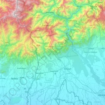
Naam: Topografische kaart Darjeeling district, hoogte, reliëf.
Locatie: Darjeeling district, West Bengal, India (26.44839 87.98729 27.22120 88.51264)
Gemiddelde hoogte: 728 m
Minimale hoogte: 70 m
Maximale hoogte: 3.595 m
The Darjeeling hill area is formed of comparatively recent rock structure that has a direct bearing on landslides. Heavy monsoon precipitation contributes to the landslides. Soils of Darjeeling hill areas are extremely varied, depending on elevation, degree of slope, vegetative cover and geolithology.
Andere topografische kaarten
Klik op een kaart om zijn topografie, zijn hoogte en zijn reliëf te bekijken.
Siliguri
India > West Bengal > Siliguri Subdivsion
Siliguri, Siliguri Subdivsion, Darjeeling District, West Bengal, India
Gemiddelde hoogte: 121 m
Bangaon
India > West Bengal > Bongaon
Bangaon, Bongaon, North 24 Parganas District, West Bengal, 743235, India
Gemiddelde hoogte: 7 m
Taki
India > West Bengal > Hasnabad
Taki, Hasnabad, North 24 Parganas District, West Bengal, 743429, India
Gemiddelde hoogte: 4 m
Thakurpukur Maheshtala
Thakurpukur Maheshtala, South 24 Parganas District, West Bengal, India
Gemiddelde hoogte: 5 m
Rajganj
India > West Bengal > Rajganj
Rajganj, Jalpaiguri District, West Bengal, 735134, India
Gemiddelde hoogte: 93 m
Kolkata
Kolkata, Kolkata District, West Bengal, 700073, India
Gemiddelde hoogte: 5 m
Swabhumi
India > West Bengal > Kolkata
Swabhumi, Kolkata, Kolkata District, West Bengal, India
Gemiddelde hoogte: 6 m
Mathurapur - I
Mathurapur - I, South 24 Parganas District, West Bengal, 743354, India
Gemiddelde hoogte: 4 m
Bidhannagar
Bidhannagar, North 24 Parganas District, West Bengal, India
Gemiddelde hoogte: 5 m
Bhangar - I
Bhangar - I, South 24 Parganas District, West Bengal, 743502, India
Gemiddelde hoogte: 3 m
Bolpur
India > West Bengal > Bolpur Sriniketan
Bolpur, Bolpur Sriniketan, Birbhum District, West Bengal, India
Gemiddelde hoogte: 50 m
West Dinājpur
West Dinājpur, Dakshin Dinajpur District, West Bengal, India
Gemiddelde hoogte: 34 m
Medinipur
India > West Bengal > Midnapore
Medinipur, Midnapore, Paschim Medinipur District, West Bengal, 721101, India
Gemiddelde hoogte: 39 m
Rampurhat
India > West Bengal > Rampurhat - I
Rampurhat, Rampurhat - I, Birbhum District, West Bengal, 731224, India
Gemiddelde hoogte: 38 m
Gangapur
India > West Bengal > Barasat - I
Gangapur, Barasat - I, North 24 Parganas District, West Bengal, 743248, India
Gemiddelde hoogte: 7 m
Baranagar
India > West Bengal > Barrackpore
Baranagar, Barrackpore, North 24 Parganas District, West Bengal, 700035, India
Gemiddelde hoogte: 6 m
Asansol Kulti Township
Asansol Kulti Township, Paschim Bardhaman District, West Bengal, India
Gemiddelde hoogte: 125 m
Kolkata
Kolkata, Kolkata District, West Bengal, India, Adi Ganga
Gemiddelde hoogte: 8 m
Kharagpur
India > West Bengal > Kharagpur-I
Kharagpur, Kharagpur-I, Paschim Medinipur District, West Bengal, 721301, India
Gemiddelde hoogte: 39 m
Raiganj
Raiganj, Uttar Dinajpur District, West Bengal, India
Gemiddelde hoogte: 35 m
B-13
India > West Bengal > Kalyani
B-13, Kalyani, Nadia District, West Bengal, India
Gemiddelde hoogte: 10 m
North Dumdum
India > West Bengal > Barrackpore
North Dumdum, Barrackpore, North 24 Parganas District, West Bengal, 700051, India
Gemiddelde hoogte: 7 m
Garbeta-III
Garbeta-III, Paschim Medinipur District, West Bengal, 721253, India
Gemiddelde hoogte: 42 m
South 24 Parganas District
South 24 Parganas District, West Bengal, India
Gemiddelde hoogte: 3 m
Kangsabati Reservoir
India > West Bengal > Ranibundh
Kangsabati Reservoir, Ranibundh, Bankura District, West Bengal, India
Gemiddelde hoogte: 136 m
Ghatal
Ghatal, Paschim Medinipur District, West Bengal, India
Gemiddelde hoogte: 11 m
Malda
India > West Bengal > English Bazar
Malda, English Bazar, Maldah, West Bengal, 732101, India
Gemiddelde hoogte: 26 m
Tufanganj - I
Tufanganj - I, Cooch Behar District, West Bengal, India
Gemiddelde hoogte: 37 m
Dum Dum
India > West Bengal > Barrackpore
Dum Dum, Barrackpore, North 24 Parganas District, West Bengal, 700081, India
Gemiddelde hoogte: 6 m
Darjeeling Pulbazar
Darjeeling Pulbazar, Darjeeling District, West Bengal, India
Gemiddelde hoogte: 1.779 m
Chandipur
Chandipur, Purba Medinipur District, West Bengal, 721659, India
Gemiddelde hoogte: 4 m
Digha
India > West Bengal > Digha
Digha, Ramnagar-I, Purba Medinipur, West Bengal, 721428, India
Gemiddelde hoogte: 4 m
Shiulibari
India > West Bengal > Contai-III
Shiulibari, Contai-III, Purba Medinipur District, West Bengal, 721449, India
Gemiddelde hoogte: 4 m
Bikna
India > West Bengal > Bankura - II
Bikna, Bankura - II, Bankura District, West Bengal, 722180, India
Gemiddelde hoogte: 85 m
Bishnupur - II
Bishnupur - II, South 24 Parganas District, West Bengal, 743377, India
Gemiddelde hoogte: 4 m
Diamond Harbour - II
Diamond Harbour - II, South 24 Parganas, West Bengal, 743368, India
Gemiddelde hoogte: 3 m
Bhangar - II
Bhangar - II, South 24 Parganas, West Bengal, India
Gemiddelde hoogte: 4 m
Krishnanagar
India > West Bengal > Krishnagar-I > Krishnanagar
Krishnanagar, Krishnagar-I, Nadia, West Bengal, 741101, India
Gemiddelde hoogte: 11 m
Sevoke
India > West Bengal > Sevoke
Sevoke, Darjiling, Darjeeling, West Bengal, India
Gemiddelde hoogte: 254 m
Cooch Behar
India > West Bengal > Cooch Behar
Cooch Behar, Koch Bihār, Kochbihar, West Bengal, 736101, India
Gemiddelde hoogte: 43 m
Sagar Island
Sagar Island, Sagar, South 24 Parganas, West Bengal, 743606, India
Gemiddelde hoogte: 2 m
Damdim
India > West Bengal > Mal
Damdim, Mal, Jalpaiguri District, West Bengal, 735209, India
Gemiddelde hoogte: 161 m